You are here: Home > Network List > CI - Caltech Regional Seismic Network Stations List
> Station GLA Glamis, California, USA > Earthquake Result Viewer
GLA Glamis, California, USA - Earthquake Result Viewer
| Earthquake location: |
Near Coast Of Peru |
| Earthquake latitude/longitude: |
-17.5/-72.1 |
| Earthquake time(UTC): |
2001/07/07 (188) 09:38:43 GMT |
| Earthquake Depth: |
33 km |
| Earthquake Magnitude: |
6.6 MB, 7.3 MS, 7.6 MW, 7.5 ME |
| Earthquake Catalog/Contributor: |
WHDF/NEIC |
|
| Network: |
CI Caltech Regional Seismic Network |
| Station: |
GLA Glamis, California, USA |
| Lat/Lon: |
33.05 N/114.83 W |
| Elevation: |
627 m |
|
| Distance: |
64.8 deg |
| Az: |
320.946 deg |
| Baz: |
134.296 deg |
| Ray Param: |
0.05863699 |
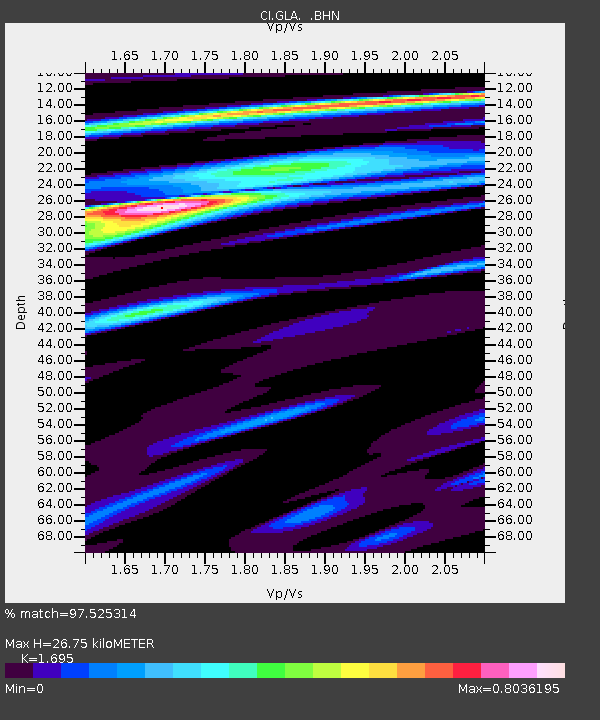
| Estimated Moho Depth: |
26.75 km |
| Estimated Crust Vp/Vs: |
1.70 |
| Assumed Crust Vp: |
6.155 km/s |
| Estimated Crust Vs: |
3.631 km/s |
| Estimated Crust Poisson's Ratio: |
0.23 |
|
| Radial Match: |
97.525314 % |
| Radial Bump: |
386 |
| Transverse Match: |
88.95523 % |
| Transverse Bump: |
400 |
| SOD ConfigId: |
3770 |
| Insert Time: |
2010-02-25 21:42:58.904 +0000 |
| GWidth: |
2.5 |
| Max Bumps: |
400 |
| Tol: |
0.001 |
|
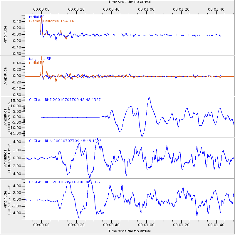
Signal To Noise
| Channel | StoN | STA | LTA |
| CI:GLA: :BHN:20010707T09:48:48.132Z | 1.0554228 | 1.6781094E-7 | 1.5899879E-7 |
| CI:GLA: :BHE:20010707T09:48:48.132Z | 2.0137465 | 1.5239918E-7 | 7.567942E-8 |
| CI:GLA: :BHZ:20010707T09:48:48.132Z | 3.4367898 | 3.047534E-7 | 8.867386E-8 |
| Arrivals |
| Ps | 3.1 SECOND |
| PpPs | 11 SECOND |
| PsPs/PpSs | 14 SECOND |


