You are here: Home > Network List > TA - USArray Transportable Network (new EarthScope stations) Stations List
> Station 833A Chaparral WMA, Artesia Wells, TX, USA > Earthquake Result Viewer
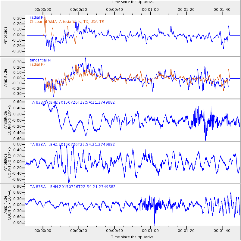
833A Chaparral WMA, Artesia Wells, TX, USA - Earthquake Result Viewer
*The percent match for this event was below the threshold and hence no stack was calculated.
| Earthquake location: |
Tonga Islands |
| Earthquake latitude/longitude: |
-18.0/-174.1 |
| Earthquake time(UTC): |
2015/07/26 (207) 22:42:15 GMT |
| Earthquake Depth: |
29 km |
| Earthquake Magnitude: |
5.5 MB |
| Earthquake Catalog/Contributor: |
NEIC PDE/NEIC ALERT |
|
| Network: |
TA USArray Transportable Network (new EarthScope stations) |
| Station: |
833A Chaparral WMA, Artesia Wells, TX, USA |
| Lat/Lon: |
28.32 N/99.39 W |
| Elevation: |
171 m |
|
| Distance: |
85.6 deg |
| Az: |
58.511 deg |
| Baz: |
246.979 deg |
| Ray Param: |
$rayparam |
*The percent match for this event was below the threshold and hence was not used in the summary stack. |
|
| Radial Match: |
49.833897 % |
| Radial Bump: |
400 |
| Transverse Match: |
25.012468 % |
| Transverse Bump: |
400 |
| SOD ConfigId: |
7422571 |
| Insert Time: |
2019-04-19 23:09:20.743 +0000 |
| GWidth: |
2.5 |
| Max Bumps: |
400 |
| Tol: |
0.001 |
|
Signal To Noise
| Channel | StoN | STA | LTA |
| TA:833A: :BHZ:20150726T22:54:21.274988Z | 0.78261095 | 1.067152E-7 | 1.3635791E-7 |
| TA:833A: :BHN:20150726T22:54:21.274988Z | 0.6940733 | 2.1131271E-7 | 3.04453E-7 |
| TA:833A: :BHE:20150726T22:54:21.274988Z | 1.0968958 | 3.3504676E-7 | 3.0544993E-7 |
| Arrivals |
| Ps | |
| PpPs | |
| PsPs/PpSs | |


