You are here: Home > Network List > IU - Global Seismograph Network (GSN - IRIS/USGS) Stations List
> Station PMG Port Moresby, New Guinea > Earthquake Result Viewer
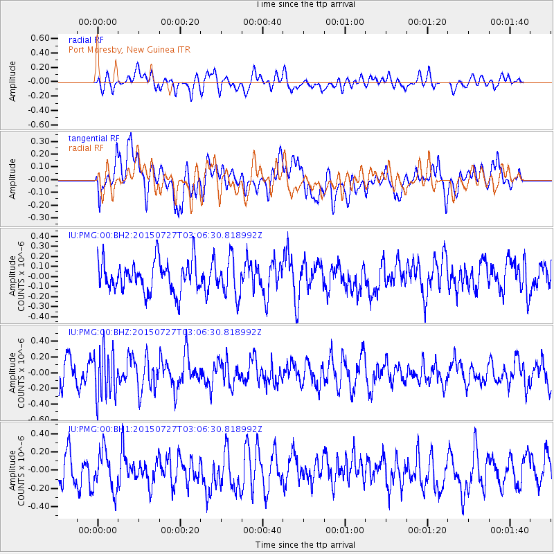
PMG Port Moresby, New Guinea - Earthquake Result Viewer
*The percent match for this event was below the threshold and hence no stack was calculated.
| Earthquake location: |
Tonga Islands Region |
| Earthquake latitude/longitude: |
-22.6/-174.4 |
| Earthquake time(UTC): |
2015/07/27 (208) 02:59:34 GMT |
| Earthquake Depth: |
10 km |
| Earthquake Magnitude: |
4.9 MW |
| Earthquake Catalog/Contributor: |
ISC/ISC |
|
| Network: |
IU Global Seismograph Network (GSN - IRIS/USGS) |
| Station: |
PMG Port Moresby, New Guinea |
| Lat/Lon: |
9.40 S/147.16 E |
| Elevation: |
90 m |
|
| Distance: |
39.0 deg |
| Az: |
283.409 deg |
| Baz: |
114.395 deg |
| Ray Param: |
$rayparam |
*The percent match for this event was below the threshold and hence was not used in the summary stack. |
|
| Radial Match: |
46.5244 % |
| Radial Bump: |
400 |
| Transverse Match: |
48.850346 % |
| Transverse Bump: |
400 |
| SOD ConfigId: |
7422571 |
| Insert Time: |
2019-04-19 23:21:47.502 +0000 |
| GWidth: |
2.5 |
| Max Bumps: |
400 |
| Tol: |
0.001 |
|
Signal To Noise
| Channel | StoN | STA | LTA |
| IU:PMG:00:BHZ:20150727T03:06:30.818992Z | 1.6960307 | 2.988251E-7 | 1.7619087E-7 |
| IU:PMG:00:BH1:20150727T03:06:30.818992Z | 1.5316168 | 2.2107693E-7 | 1.443422E-7 |
| IU:PMG:00:BH2:20150727T03:06:30.818992Z | 1.2665715 | 1.9155372E-7 | 1.5123798E-7 |
| Arrivals |
| Ps | |
| PpPs | |
| PsPs/PpSs | |


