You are here: Home > Network List > GS - US Geological Survey Networks Stations List
> Station KAN11 Stewart Ranch, Harper County, KS, USA > Earthquake Result Viewer
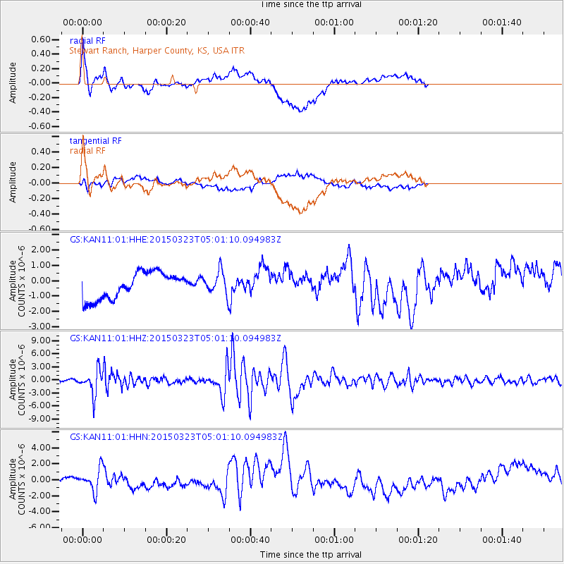
KAN11 Stewart Ranch, Harper County, KS, USA - Earthquake Result Viewer
*The percent match for this event was below the threshold and hence no stack was calculated.
| Earthquake location: |
Northern Chile |
| Earthquake latitude/longitude: |
-18.4/-69.4 |
| Earthquake time(UTC): |
2015/03/23 (082) 04:51:37 GMT |
| Earthquake Depth: |
128 km |
| Earthquake Magnitude: |
6.1 MWP, 6.1 MO |
| Earthquake Catalog/Contributor: |
NEIC PDE/NEIC ALERT |
|
| Network: |
GS US Geological Survey Networks |
| Station: |
KAN11 Stewart Ranch, Harper County, KS, USA |
| Lat/Lon: |
37.21 N/97.91 W |
| Elevation: |
410 m |
|
| Distance: |
61.5 deg |
| Az: |
334.277 deg |
| Baz: |
148.933 deg |
| Ray Param: |
$rayparam |
*The percent match for this event was below the threshold and hence was not used in the summary stack. |
|
| Radial Match: |
52.9449 % |
| Radial Bump: |
400 |
| Transverse Match: |
53.92854 % |
| Transverse Bump: |
400 |
| SOD ConfigId: |
872571 |
| Insert Time: |
2015-04-06 05:06:23.109 +0000 |
| GWidth: |
2.5 |
| Max Bumps: |
400 |
| Tol: |
0.001 |
|
Signal To Noise
| Channel | StoN | STA | LTA |
| GS:KAN11:01:HHZ:20150323T05:01:10.094983Z | 15.386583 | 2.8237564E-6 | 1.835207E-7 |
| GS:KAN11:01:HHN:20150323T05:01:10.094983Z | 2.4983156 | 1.4175621E-6 | 5.6740714E-7 |
| GS:KAN11:01:HHE:20150323T05:01:10.094983Z | 0.8958555 | 7.659126E-7 | 8.5495105E-7 |
| Arrivals |
| Ps | |
| PpPs | |
| PsPs/PpSs | |


