You are here: Home > Network List > 7A - Mid-Atlantic Geophysical Integrative Collaboration Stations List
> Station DENI Denison University at Granville, Ohio USA > Earthquake Result Viewer
DENI Denison University at Granville, Ohio USA - Earthquake Result Viewer
| Earthquake location: |
Fox Islands, Aleutian Islands |
| Earthquake latitude/longitude: |
52.4/-169.7 |
| Earthquake time(UTC): |
2015/07/27 (208) 04:49:44 GMT |
| Earthquake Depth: |
12 km |
| Earthquake Magnitude: |
6.9 MO |
| Earthquake Catalog/Contributor: |
NEIC PDE/NEIC ALERT |
|
| Network: |
7A Mid-Atlantic Geophysical Integrative Collaboration |
| Station: |
DENI Denison University at Granville, Ohio USA |
| Lat/Lon: |
40.08 N/82.53 W |
| Elevation: |
315 m |
|
| Distance: |
58.0 deg |
| Az: |
64.662 deg |
| Baz: |
313.767 deg |
| Ray Param: |
0.06313998 |
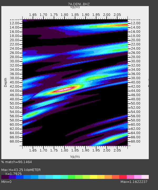
| Estimated Moho Depth: |
43.25 km |
| Estimated Crust Vp/Vs: |
1.79 |
| Assumed Crust Vp: |
6.498 km/s |
| Estimated Crust Vs: |
3.625 km/s |
| Estimated Crust Poisson's Ratio: |
0.27 |
|
| Radial Match: |
98.1464 % |
| Radial Bump: |
322 |
| Transverse Match: |
88.749954 % |
| Transverse Bump: |
400 |
| SOD ConfigId: |
7422571 |
| Insert Time: |
2019-04-19 23:25:28.964 +0000 |
| GWidth: |
2.5 |
| Max Bumps: |
400 |
| Tol: |
0.001 |
|

Signal To Noise
| Channel | StoN | STA | LTA |
| 7A:DENI: :BHZ:20150727T04:59:04.639978Z | 25.22333 | 1.8969023E-6 | 7.520428E-8 |
| 7A:DENI: :BHN:20150727T04:59:04.639978Z | 10.625627 | 6.8729696E-7 | 6.468296E-8 |
| 7A:DENI: :BHE:20150727T04:59:04.639978Z | 10.730194 | 7.407075E-7 | 6.903021E-8 |
| Arrivals |
| Ps | 5.5 SECOND |
| PpPs | 18 SECOND |
| PsPs/PpSs | 23 SECOND |


