You are here: Home > Network List > 7A - Mid-Atlantic Geophysical Integrative Collaboration Stations List
> Station RTSN Coon Bone Island, West Virginia USA > Earthquake Result Viewer
RTSN Coon Bone Island, West Virginia USA - Earthquake Result Viewer
| Earthquake location: |
Fox Islands, Aleutian Islands |
| Earthquake latitude/longitude: |
52.4/-169.7 |
| Earthquake time(UTC): |
2015/07/27 (208) 04:49:44 GMT |
| Earthquake Depth: |
12 km |
| Earthquake Magnitude: |
6.9 MO |
| Earthquake Catalog/Contributor: |
NEIC PDE/NEIC ALERT |
|
| Network: |
7A Mid-Atlantic Geophysical Integrative Collaboration |
| Station: |
RTSN Coon Bone Island, West Virginia USA |
| Lat/Lon: |
38.94 N/79.58 W |
| Elevation: |
949 m |
|
| Distance: |
60.4 deg |
| Az: |
63.748 deg |
| Baz: |
315.166 deg |
| Ray Param: |
0.061552852 |
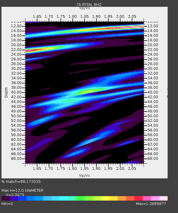
| Estimated Moho Depth: |
12.0 km |
| Estimated Crust Vp/Vs: |
2.09 |
| Assumed Crust Vp: |
6.159 km/s |
| Estimated Crust Vs: |
2.95 km/s |
| Estimated Crust Poisson's Ratio: |
0.35 |
|
| Radial Match: |
98.172035 % |
| Radial Bump: |
400 |
| Transverse Match: |
90.99711 % |
| Transverse Bump: |
400 |
| SOD ConfigId: |
7422571 |
| Insert Time: |
2019-04-19 23:25:38.386 +0000 |
| GWidth: |
2.5 |
| Max Bumps: |
400 |
| Tol: |
0.001 |
|

Signal To Noise
| Channel | StoN | STA | LTA |
| 7A:RTSN: :BHZ:20150727T04:59:21.389978Z | 25.39855 | 2.5305915E-6 | 9.963528E-8 |
| 7A:RTSN: :BHN:20150727T04:59:21.389978Z | 13.49304 | 8.428802E-7 | 6.246778E-8 |
| 7A:RTSN: :BHE:20150727T04:59:21.389978Z | 14.294907 | 8.6886047E-7 | 6.0781126E-8 |
| Arrivals |
| Ps | 2.2 SECOND |
| PpPs | 5.8 SECOND |
| PsPs/PpSs | 8.0 SECOND |


