You are here: Home > Network List > 7A - Mid-Atlantic Geophysical Integrative Collaboration Stations List
> Station WIRE Hazelwood, West Virginia USA > Earthquake Result Viewer
WIRE Hazelwood, West Virginia USA - Earthquake Result Viewer
| Earthquake location: |
Fox Islands, Aleutian Islands |
| Earthquake latitude/longitude: |
52.4/-169.7 |
| Earthquake time(UTC): |
2015/07/27 (208) 04:49:44 GMT |
| Earthquake Depth: |
12 km |
| Earthquake Magnitude: |
6.9 MO |
| Earthquake Catalog/Contributor: |
NEIC PDE/NEIC ALERT |
|
| Network: |
7A Mid-Atlantic Geophysical Integrative Collaboration |
| Station: |
WIRE Hazelwood, West Virginia USA |
| Lat/Lon: |
38.85 N/79.84 W |
| Elevation: |
613 m |
|
| Distance: |
60.3 deg |
| Az: |
63.983 deg |
| Baz: |
315.123 deg |
| Ray Param: |
0.0616038 |
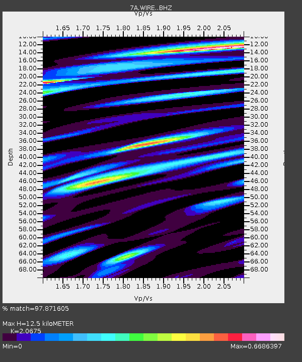
| Estimated Moho Depth: |
12.5 km |
| Estimated Crust Vp/Vs: |
2.07 |
| Assumed Crust Vp: |
6.159 km/s |
| Estimated Crust Vs: |
2.979 km/s |
| Estimated Crust Poisson's Ratio: |
0.35 |
|
| Radial Match: |
97.871605 % |
| Radial Bump: |
400 |
| Transverse Match: |
94.146805 % |
| Transverse Bump: |
400 |
| SOD ConfigId: |
7422571 |
| Insert Time: |
2019-04-19 23:25:39.712 +0000 |
| GWidth: |
2.5 |
| Max Bumps: |
400 |
| Tol: |
0.001 |
|

Signal To Noise
| Channel | StoN | STA | LTA |
| 7A:WIRE: :BHZ:20150727T04:59:20.83999Z | 30.964264 | 2.3975558E-6 | 7.742977E-8 |
| 7A:WIRE: :BHN:20150727T04:59:20.83999Z | 12.993406 | 8.129932E-7 | 6.2569676E-8 |
| 7A:WIRE: :BHE:20150727T04:59:20.83999Z | 15.628785 | 8.9698995E-7 | 5.7393454E-8 |
| Arrivals |
| Ps | 2.2 SECOND |
| PpPs | 6.0 SECOND |
| PsPs/PpSs | 8.3 SECOND |


