You are here: Home > Network List > CC - Cascade Chain Volcano Monitoring Stations List
> Station TMBU Tom Butte, Newberry, OR > Earthquake Result Viewer
TMBU Tom Butte, Newberry, OR - Earthquake Result Viewer
| Earthquake location: |
Fox Islands, Aleutian Islands |
| Earthquake latitude/longitude: |
52.4/-169.7 |
| Earthquake time(UTC): |
2015/07/27 (208) 04:49:44 GMT |
| Earthquake Depth: |
12 km |
| Earthquake Magnitude: |
6.9 MO |
| Earthquake Catalog/Contributor: |
NEIC PDE/NEIC ALERT |
|
| Network: |
CC Cascade Chain Volcano Monitoring |
| Station: |
TMBU Tom Butte, Newberry, OR |
| Lat/Lon: |
43.60 N/121.14 W |
| Elevation: |
1743 m |
|
| Distance: |
33.1 deg |
| Az: |
85.682 deg |
| Baz: |
302.702 deg |
| Ray Param: |
0.07837086 |
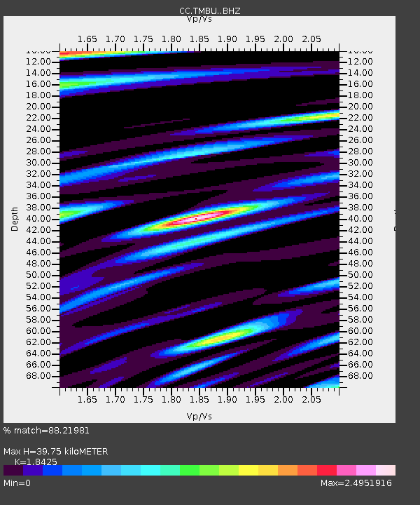
| Estimated Moho Depth: |
39.75 km |
| Estimated Crust Vp/Vs: |
1.84 |
| Assumed Crust Vp: |
6.597 km/s |
| Estimated Crust Vs: |
3.581 km/s |
| Estimated Crust Poisson's Ratio: |
0.29 |
|
| Radial Match: |
88.21981 % |
| Radial Bump: |
400 |
| Transverse Match: |
72.79617 % |
| Transverse Bump: |
400 |
| SOD ConfigId: |
7422571 |
| Insert Time: |
2019-04-19 23:26:52.469 +0000 |
| GWidth: |
2.5 |
| Max Bumps: |
400 |
| Tol: |
0.001 |
|

Signal To Noise
| Channel | StoN | STA | LTA |
| CC:TMBU: :BHZ:20150727T04:55:47.86001Z | 8.387437 | 1.2013579E-6 | 1.4323302E-7 |
| CC:TMBU: :BHN:20150727T04:55:47.86001Z | 1.5807518 | 2.7105702E-7 | 1.7147347E-7 |
| CC:TMBU: :BHE:20150727T04:55:47.86001Z | 2.6381748 | 8.782656E-7 | 3.3290652E-7 |
| Arrivals |
| Ps | 5.5 SECOND |
| PpPs | 16 SECOND |
| PsPs/PpSs | 21 SECOND |


