You are here: Home > Network List > CI - Caltech Regional Seismic Network Stations List
> Station EDW2 EDW2, Mojave, CA, USA > Earthquake Result Viewer
EDW2 EDW2, Mojave, CA, USA - Earthquake Result Viewer
| Earthquake location: |
Fox Islands, Aleutian Islands |
| Earthquake latitude/longitude: |
52.4/-169.7 |
| Earthquake time(UTC): |
2015/07/27 (208) 04:49:44 GMT |
| Earthquake Depth: |
12 km |
| Earthquake Magnitude: |
6.9 MO |
| Earthquake Catalog/Contributor: |
NEIC PDE/NEIC ALERT |
|
| Network: |
CI Caltech Regional Seismic Network |
| Station: |
EDW2 EDW2, Mojave, CA, USA |
| Lat/Lon: |
34.88 N/117.99 W |
| Elevation: |
772 m |
|
| Distance: |
40.3 deg |
| Az: |
94.776 deg |
| Baz: |
312.005 deg |
| Ray Param: |
0.07445893 |
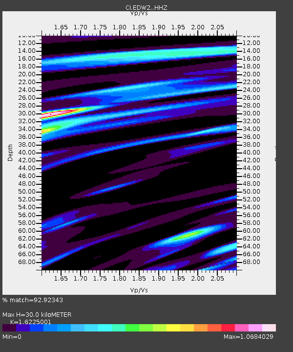
| Estimated Moho Depth: |
30.0 km |
| Estimated Crust Vp/Vs: |
1.62 |
| Assumed Crust Vp: |
6.276 km/s |
| Estimated Crust Vs: |
3.868 km/s |
| Estimated Crust Poisson's Ratio: |
0.19 |
|
| Radial Match: |
92.92343 % |
| Radial Bump: |
385 |
| Transverse Match: |
75.24743 % |
| Transverse Bump: |
400 |
| SOD ConfigId: |
7422571 |
| Insert Time: |
2019-04-19 23:27:10.838 +0000 |
| GWidth: |
2.5 |
| Max Bumps: |
400 |
| Tol: |
0.001 |
|
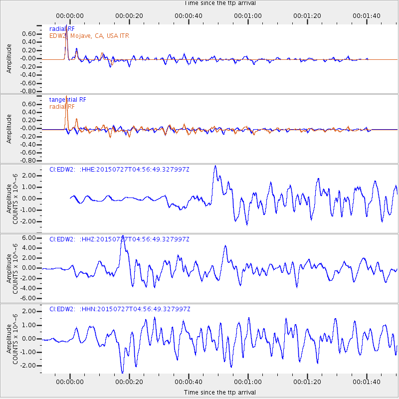
Signal To Noise
| Channel | StoN | STA | LTA |
| CI:EDW2: :HHZ:20150727T04:56:49.327997Z | 10.229881 | 7.9299076E-7 | 7.75171E-8 |
| CI:EDW2: :HHN:20150727T04:56:49.327997Z | 4.0556154 | 3.6761733E-7 | 9.064403E-8 |
| CI:EDW2: :HHE:20150727T04:56:49.327997Z | 2.582199 | 4.1648943E-7 | 1.6129253E-7 |
| Arrivals |
| Ps | 3.2 SECOND |
| PpPs | 12 SECOND |
| PsPs/PpSs | 15 SECOND |


