You are here: Home > Network List > CI - Caltech Regional Seismic Network Stations List
> Station MPP McPhearson Peak > Earthquake Result Viewer
MPP McPhearson Peak - Earthquake Result Viewer
| Earthquake location: |
Fox Islands, Aleutian Islands |
| Earthquake latitude/longitude: |
52.4/-169.7 |
| Earthquake time(UTC): |
2015/07/27 (208) 04:49:44 GMT |
| Earthquake Depth: |
12 km |
| Earthquake Magnitude: |
6.9 MO |
| Earthquake Catalog/Contributor: |
NEIC PDE/NEIC ALERT |
|
| Network: |
CI Caltech Regional Seismic Network |
| Station: |
MPP McPhearson Peak |
| Lat/Lon: |
34.89 N/119.81 W |
| Elevation: |
1739 m |
|
| Distance: |
39.2 deg |
| Az: |
96.335 deg |
| Baz: |
312.167 deg |
| Ray Param: |
0.07511134 |
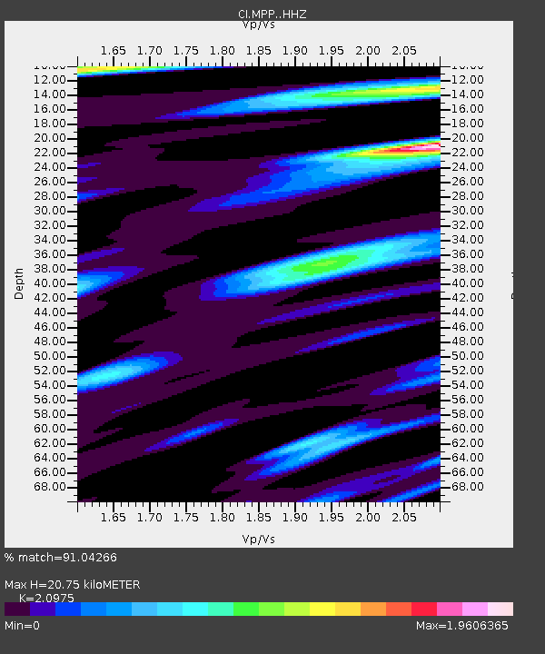
| Estimated Moho Depth: |
20.75 km |
| Estimated Crust Vp/Vs: |
2.10 |
| Assumed Crust Vp: |
6.1 km/s |
| Estimated Crust Vs: |
2.908 km/s |
| Estimated Crust Poisson's Ratio: |
0.35 |
|
| Radial Match: |
91.04266 % |
| Radial Bump: |
400 |
| Transverse Match: |
84.819855 % |
| Transverse Bump: |
400 |
| SOD ConfigId: |
7422571 |
| Insert Time: |
2019-04-19 23:27:24.699 +0000 |
| GWidth: |
2.5 |
| Max Bumps: |
400 |
| Tol: |
0.001 |
|
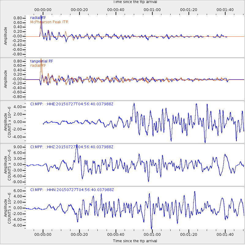
Signal To Noise
| Channel | StoN | STA | LTA |
| CI:MPP: :HHZ:20150727T04:56:40.037988Z | 6.16523 | 1.3066141E-6 | 2.1193274E-7 |
| CI:MPP: :HHN:20150727T04:56:40.037988Z | 2.1209307 | 6.078415E-7 | 2.865919E-7 |
| CI:MPP: :HHE:20150727T04:56:40.037988Z | 2.6932697 | 7.020971E-7 | 2.6068577E-7 |
| Arrivals |
| Ps | 3.9 SECOND |
| PpPs | 10.0 SECOND |
| PsPs/PpSs | 14 SECOND |


