You are here: Home > Network List > CN - Canadian National Seismograph Network Stations List
> Station A61 Sainte Mathilde, QC, CA > Earthquake Result Viewer
A61 Sainte Mathilde, QC, CA - Earthquake Result Viewer
| Earthquake location: |
Fox Islands, Aleutian Islands |
| Earthquake latitude/longitude: |
52.4/-169.7 |
| Earthquake time(UTC): |
2015/07/27 (208) 04:49:44 GMT |
| Earthquake Depth: |
12 km |
| Earthquake Magnitude: |
6.9 MO |
| Earthquake Catalog/Contributor: |
NEIC PDE/NEIC ALERT |
|
| Network: |
CN Canadian National Seismograph Network |
| Station: |
A61 Sainte Mathilde, QC, CA |
| Lat/Lon: |
47.69 N/70.09 W |
| Elevation: |
380 m |
|
| Distance: |
59.1 deg |
| Az: |
50.935 deg |
| Baz: |
315.204 deg |
| Ray Param: |
0.06241344 |
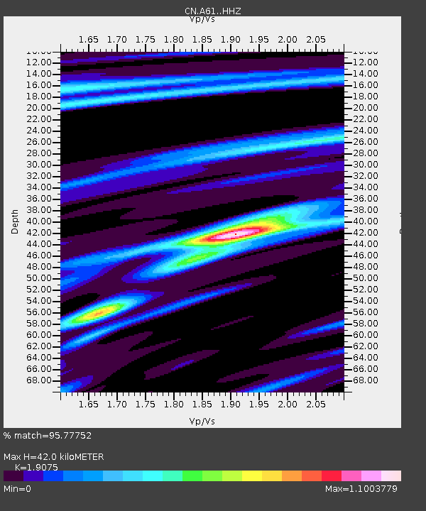
| Estimated Moho Depth: |
42.0 km |
| Estimated Crust Vp/Vs: |
1.91 |
| Assumed Crust Vp: |
6.61 km/s |
| Estimated Crust Vs: |
3.465 km/s |
| Estimated Crust Poisson's Ratio: |
0.31 |
|
| Radial Match: |
95.77752 % |
| Radial Bump: |
400 |
| Transverse Match: |
87.443756 % |
| Transverse Bump: |
400 |
| SOD ConfigId: |
7422571 |
| Insert Time: |
2019-04-19 23:27:50.912 +0000 |
| GWidth: |
2.5 |
| Max Bumps: |
400 |
| Tol: |
0.001 |
|

Signal To Noise
| Channel | StoN | STA | LTA |
| CN:A61: :HHZ:20150727T04:59:12.569971Z | 24.418589 | 3.153371E-6 | 1.2913814E-7 |
| CN:A61: :HHN:20150727T04:59:12.569971Z | 10.378731 | 9.821287E-7 | 9.462898E-8 |
| CN:A61: :HHE:20150727T04:59:12.569971Z | 13.708153 | 1.0745414E-6 | 7.8387025E-8 |
| Arrivals |
| Ps | 6.0 SECOND |
| PpPs | 18 SECOND |
| PsPs/PpSs | 24 SECOND |


