You are here: Home > Network List > DK - Danish Seismological Network Stations List
> Station ILULI Ilulissat, Greenland > Earthquake Result Viewer
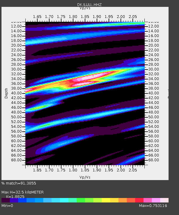
ILULI Ilulissat, Greenland - Earthquake Result Viewer
| Earthquake location: |
Fox Islands, Aleutian Islands |
| Earthquake latitude/longitude: |
52.4/-169.7 |
| Earthquake time(UTC): |
2015/07/27 (208) 04:49:44 GMT |
| Earthquake Depth: |
12 km |
| Earthquake Magnitude: |
6.9 MO |
| Earthquake Catalog/Contributor: |
NEIC PDE/NEIC ALERT |
|
| Network: |
DK Danish Seismological Network |
| Station: |
ILULI Ilulissat, Greenland |
| Lat/Lon: |
69.21 N/51.10 W |
| Elevation: |
54 m |
|
| Distance: |
50.7 deg |
| Az: |
23.905 deg |
| Baz: |
315.904 deg |
| Ray Param: |
0.06787509 |
| Estimated Moho Depth: |
32.5 km |
| Estimated Crust Vp/Vs: |
1.88 |
| Assumed Crust Vp: |
6.459 km/s |
| Estimated Crust Vs: |
3.431 km/s |
| Estimated Crust Poisson's Ratio: |
0.30 |
|
| Radial Match: |
91.3855 % |
| Radial Bump: |
325 |
| Transverse Match: |
68.191696 % |
| Transverse Bump: |
400 |
| SOD ConfigId: |
7422571 |
| Insert Time: |
2019-04-19 23:28:16.122 +0000 |
| GWidth: |
2.5 |
| Max Bumps: |
400 |
| Tol: |
0.001 |
|

Signal To Noise
| Channel | StoN | STA | LTA |
| DK:ILULI: :HHZ:20150727T04:58:12.428003Z | 34.46707 | 3.0927606E-6 | 8.9730875E-8 |
| DK:ILULI: :HHN:20150727T04:58:12.428003Z | 12.270511 | 1.329273E-6 | 1.08330696E-7 |
| DK:ILULI: :HHE:20150727T04:58:12.428003Z | 12.435656 | 1.0912811E-6 | 8.775421E-8 |
| Arrivals |
| Ps | 4.7 SECOND |
| PpPs | 14 SECOND |
| PsPs/PpSs | 18 SECOND |


