You are here: Home > Network List > IW - Intermountain West Stations List
> Station MFID Camas Ranch, Mayfield, ID, USA > Earthquake Result Viewer
MFID Camas Ranch, Mayfield, ID, USA - Earthquake Result Viewer
| Earthquake location: |
Northern Chile |
| Earthquake latitude/longitude: |
-18.4/-69.4 |
| Earthquake time(UTC): |
2015/03/23 (082) 04:51:37 GMT |
| Earthquake Depth: |
128 km |
| Earthquake Magnitude: |
6.1 MWP, 6.1 MO |
| Earthquake Catalog/Contributor: |
NEIC PDE/NEIC ALERT |
|
| Network: |
IW Intermountain West |
| Station: |
MFID Camas Ranch, Mayfield, ID, USA |
| Lat/Lon: |
43.42 N/115.83 W |
| Elevation: |
1302 m |
|
| Distance: |
74.9 deg |
| Az: |
326.821 deg |
| Baz: |
134.525 deg |
| Ray Param: |
0.051741842 |
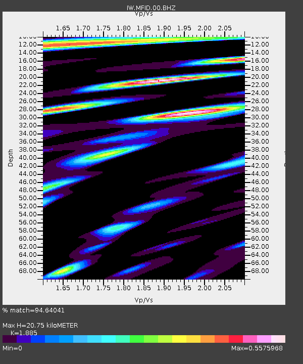
| Estimated Moho Depth: |
20.75 km |
| Estimated Crust Vp/Vs: |
1.88 |
| Assumed Crust Vp: |
6.291 km/s |
| Estimated Crust Vs: |
3.338 km/s |
| Estimated Crust Poisson's Ratio: |
0.30 |
|
| Radial Match: |
94.64041 % |
| Radial Bump: |
400 |
| Transverse Match: |
85.0065 % |
| Transverse Bump: |
400 |
| SOD ConfigId: |
872571 |
| Insert Time: |
2015-04-06 05:08:17.368 +0000 |
| GWidth: |
2.5 |
| Max Bumps: |
400 |
| Tol: |
0.001 |
|

Signal To Noise
| Channel | StoN | STA | LTA |
| IW:MFID:00:BHZ:20150323T05:02:32.899976Z | 38.80327 | 2.530481E-6 | 6.521309E-8 |
| IW:MFID:00:BH1:20150323T05:02:32.899976Z | 6.6061106 | 6.4256295E-7 | 9.7267964E-8 |
| IW:MFID:00:BH2:20150323T05:02:32.899976Z | 3.73058 | 4.7671966E-7 | 1.2778702E-7 |
| Arrivals |
| Ps | 3.0 SECOND |
| PpPs | 9.2 SECOND |
| PsPs/PpSs | 12 SECOND |


