You are here: Home > Network List > N4 - Central and EAstern US Network Stations List
> Station F33B 5 Mile Ranch, Herman, MN, USA > Earthquake Result Viewer
F33B 5 Mile Ranch, Herman, MN, USA - Earthquake Result Viewer
| Earthquake location: |
Fox Islands, Aleutian Islands |
| Earthquake latitude/longitude: |
52.4/-169.7 |
| Earthquake time(UTC): |
2015/07/27 (208) 04:49:44 GMT |
| Earthquake Depth: |
12 km |
| Earthquake Magnitude: |
6.9 MO |
| Earthquake Catalog/Contributor: |
NEIC PDE/NEIC ALERT |
|
| Network: |
N4 Central and EAstern US Network |
| Station: |
F33B 5 Mile Ranch, Herman, MN, USA |
| Lat/Lon: |
45.84 N/96.29 W |
| Elevation: |
314 m |
|
| Distance: |
46.6 deg |
| Az: |
67.295 deg |
| Baz: |
306.003 deg |
| Ray Param: |
0.070564575 |
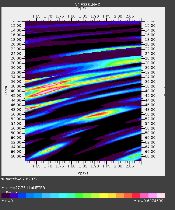
| Estimated Moho Depth: |
47.75 km |
| Estimated Crust Vp/Vs: |
1.60 |
| Assumed Crust Vp: |
6.552 km/s |
| Estimated Crust Vs: |
4.095 km/s |
| Estimated Crust Poisson's Ratio: |
0.18 |
|
| Radial Match: |
97.62377 % |
| Radial Bump: |
241 |
| Transverse Match: |
82.13711 % |
| Transverse Bump: |
400 |
| SOD ConfigId: |
7422571 |
| Insert Time: |
2019-04-19 23:31:46.606 +0000 |
| GWidth: |
2.5 |
| Max Bumps: |
400 |
| Tol: |
0.001 |
|

Signal To Noise
| Channel | StoN | STA | LTA |
| N4:F33B: :HHZ:20150727T04:57:39.939996Z | 32.075165 | 2.0372727E-6 | 6.351558E-8 |
| N4:F33B: :HHN:20150727T04:57:39.939996Z | 14.534615 | 6.846919E-7 | 4.7107676E-8 |
| N4:F33B: :HHE:20150727T04:57:39.939996Z | 24.728844 | 1.0018199E-6 | 4.05122E-8 |
| Arrivals |
| Ps | 4.7 SECOND |
| PpPs | 18 SECOND |
| PsPs/PpSs | 22 SECOND |


