You are here: Home > Network List > N4 - Central and EAstern US Network Stations List
> Station G40A Rib Lake, WI, USA > Earthquake Result Viewer
G40A Rib Lake, WI, USA - Earthquake Result Viewer
| Earthquake location: |
Fox Islands, Aleutian Islands |
| Earthquake latitude/longitude: |
52.4/-169.7 |
| Earthquake time(UTC): |
2015/07/27 (208) 04:49:44 GMT |
| Earthquake Depth: |
12 km |
| Earthquake Magnitude: |
6.9 MO |
| Earthquake Catalog/Contributor: |
NEIC PDE/NEIC ALERT |
|
| Network: |
N4 Central and EAstern US Network |
| Station: |
G40A Rib Lake, WI, USA |
| Lat/Lon: |
45.27 N/90.20 W |
| Elevation: |
472 m |
|
| Distance: |
50.3 deg |
| Az: |
64.443 deg |
| Baz: |
308.446 deg |
| Ray Param: |
0.06813663 |
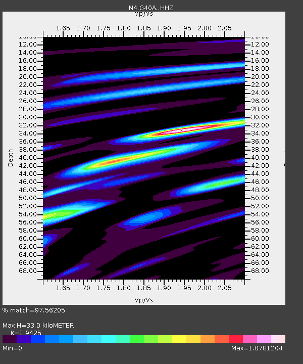
| Estimated Moho Depth: |
33.0 km |
| Estimated Crust Vp/Vs: |
1.94 |
| Assumed Crust Vp: |
6.571 km/s |
| Estimated Crust Vs: |
3.383 km/s |
| Estimated Crust Poisson's Ratio: |
0.32 |
|
| Radial Match: |
97.56205 % |
| Radial Bump: |
314 |
| Transverse Match: |
86.776085 % |
| Transverse Bump: |
400 |
| SOD ConfigId: |
7422571 |
| Insert Time: |
2019-04-19 23:31:49.871 +0000 |
| GWidth: |
2.5 |
| Max Bumps: |
400 |
| Tol: |
0.001 |
|

Signal To Noise
| Channel | StoN | STA | LTA |
| N4:G40A: :HHZ:20150727T04:58:08.86001Z | 30.62248 | 2.0578425E-6 | 6.720039E-8 |
| N4:G40A: :HHN:20150727T04:58:08.86001Z | 22.520145 | 8.713587E-7 | 3.869241E-8 |
| N4:G40A: :HHE:20150727T04:58:08.86001Z | 26.62905 | 1.0748456E-6 | 4.036365E-8 |
| Arrivals |
| Ps | 5.0 SECOND |
| PpPs | 14 SECOND |
| PsPs/PpSs | 19 SECOND |


