You are here: Home > Network List > N4 - Central and EAstern US Network Stations List
> Station S57A Dark Hallow, Roseland, VA, USA > Earthquake Result Viewer
S57A Dark Hallow, Roseland, VA, USA - Earthquake Result Viewer
| Earthquake location: |
Fox Islands, Aleutian Islands |
| Earthquake latitude/longitude: |
52.4/-169.7 |
| Earthquake time(UTC): |
2015/07/27 (208) 04:49:44 GMT |
| Earthquake Depth: |
12 km |
| Earthquake Magnitude: |
6.9 MO |
| Earthquake Catalog/Contributor: |
NEIC PDE/NEIC ALERT |
|
| Network: |
N4 Central and EAstern US Network |
| Station: |
S57A Dark Hallow, Roseland, VA, USA |
| Lat/Lon: |
37.76 N/78.95 W |
| Elevation: |
264 m |
|
| Distance: |
61.6 deg |
| Az: |
64.293 deg |
| Baz: |
315.818 deg |
| Ray Param: |
0.060773153 |
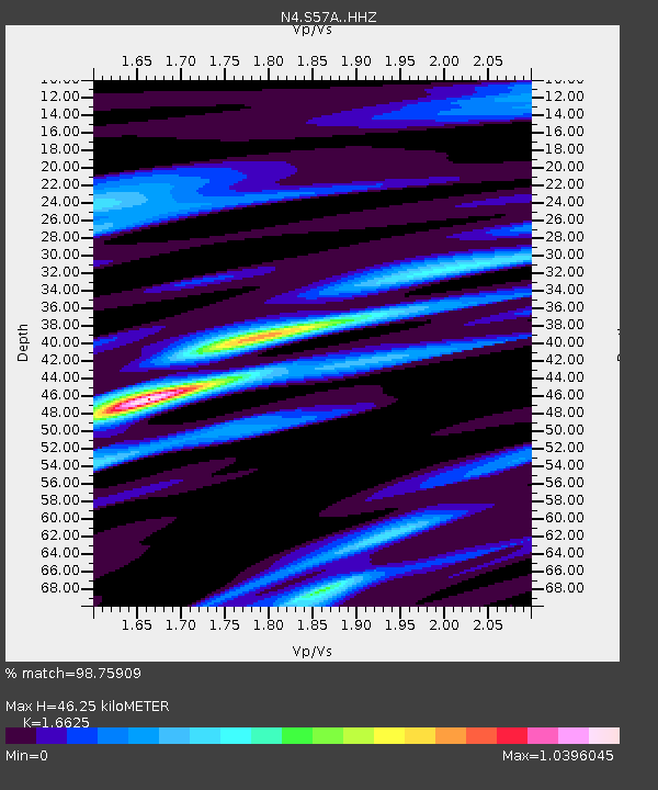
| Estimated Moho Depth: |
46.25 km |
| Estimated Crust Vp/Vs: |
1.66 |
| Assumed Crust Vp: |
6.419 km/s |
| Estimated Crust Vs: |
3.861 km/s |
| Estimated Crust Poisson's Ratio: |
0.22 |
|
| Radial Match: |
98.75909 % |
| Radial Bump: |
235 |
| Transverse Match: |
91.10964 % |
| Transverse Bump: |
400 |
| SOD ConfigId: |
7422571 |
| Insert Time: |
2019-04-19 23:32:48.921 +0000 |
| GWidth: |
2.5 |
| Max Bumps: |
400 |
| Tol: |
0.001 |
|

Signal To Noise
| Channel | StoN | STA | LTA |
| N4:S57A: :HHZ:20150727T04:59:29.420007Z | 30.918612 | 2.3412047E-6 | 7.572153E-8 |
| N4:S57A: :HHN:20150727T04:59:29.420007Z | 12.054902 | 7.400486E-7 | 6.138985E-8 |
| N4:S57A: :HHE:20150727T04:59:29.420007Z | 11.342522 | 7.8969003E-7 | 6.962209E-8 |
| Arrivals |
| Ps | 5.0 SECOND |
| PpPs | 18 SECOND |
| PsPs/PpSs | 23 SECOND |


