You are here: Home > Network List > N4 - Central and EAstern US Network Stations List
> Station S61A Accomac, VA, USA > Earthquake Result Viewer
S61A Accomac, VA, USA - Earthquake Result Viewer
| Earthquake location: |
Fox Islands, Aleutian Islands |
| Earthquake latitude/longitude: |
52.4/-169.7 |
| Earthquake time(UTC): |
2015/07/27 (208) 04:49:44 GMT |
| Earthquake Depth: |
12 km |
| Earthquake Magnitude: |
6.9 MO |
| Earthquake Catalog/Contributor: |
NEIC PDE/NEIC ALERT |
|
| Network: |
N4 Central and EAstern US Network |
| Station: |
S61A Accomac, VA, USA |
| Lat/Lon: |
37.68 N/75.67 W |
| Elevation: |
58 m |
|
| Distance: |
63.4 deg |
| Az: |
62.233 deg |
| Baz: |
316.867 deg |
| Ray Param: |
0.059569456 |
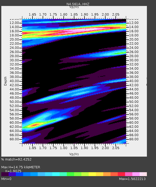
| Estimated Moho Depth: |
14.75 km |
| Estimated Crust Vp/Vs: |
1.90 |
| Assumed Crust Vp: |
5.817 km/s |
| Estimated Crust Vs: |
3.058 km/s |
| Estimated Crust Poisson's Ratio: |
0.31 |
|
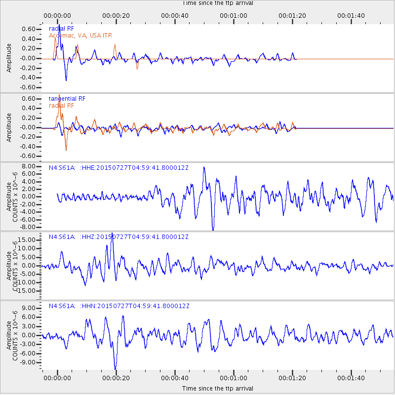
| Radial Match: |
92.4252 % |
| Radial Bump: |
314 |
| Transverse Match: |
83.80959 % |
| Transverse Bump: |
371 |
| SOD ConfigId: |
7422571 |
| Insert Time: |
2019-04-19 23:32:49.926 +0000 |
| GWidth: |
2.5 |
| Max Bumps: |
400 |
| Tol: |
0.001 |
|
Signal To Noise
| Channel | StoN | STA | LTA |
| N4:S61A: :HHZ:20150727T04:59:41.800012Z | 4.0125766 | 3.4722273E-6 | 8.6533606E-7 |
| N4:S61A: :HHN:20150727T04:59:41.800012Z | 3.853987 | 1.6376716E-6 | 4.2492923E-7 |
| N4:S61A: :HHE:20150727T04:59:41.800012Z | 2.7814171 | 1.5306141E-6 | 5.5030006E-7 |
| Arrivals |
| Ps | 2.4 SECOND |
| PpPs | 7.1 SECOND |
| PsPs/PpSs | 9.5 SECOND |


