You are here: Home > Network List > N4 - Central and EAstern US Network Stations List
> Station W45B Hickory Valley, TN, USA > Earthquake Result Viewer
W45B Hickory Valley, TN, USA - Earthquake Result Viewer
| Earthquake location: |
Fox Islands, Aleutian Islands |
| Earthquake latitude/longitude: |
52.4/-169.7 |
| Earthquake time(UTC): |
2015/07/27 (208) 04:49:44 GMT |
| Earthquake Depth: |
12 km |
| Earthquake Magnitude: |
6.9 MO |
| Earthquake Catalog/Contributor: |
NEIC PDE/NEIC ALERT |
|
| Network: |
N4 Central and EAstern US Network |
| Station: |
W45B Hickory Valley, TN, USA |
| Lat/Lon: |
35.16 N/89.19 W |
| Elevation: |
182 m |
|
| Distance: |
57.6 deg |
| Az: |
73.182 deg |
| Baz: |
314.261 deg |
| Ray Param: |
0.06339191 |
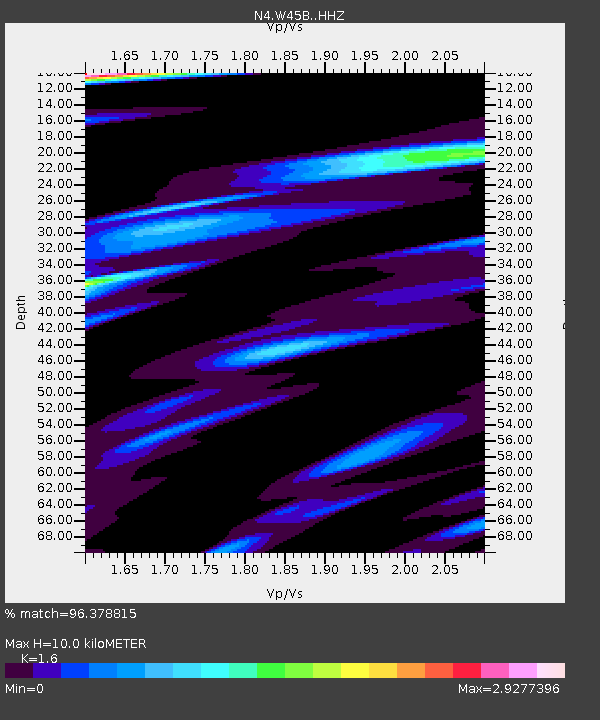
| Estimated Moho Depth: |
10.0 km |
| Estimated Crust Vp/Vs: |
1.60 |
| Assumed Crust Vp: |
6.38 km/s |
| Estimated Crust Vs: |
3.988 km/s |
| Estimated Crust Poisson's Ratio: |
0.18 |
|
| Radial Match: |
96.378815 % |
| Radial Bump: |
275 |
| Transverse Match: |
83.51327 % |
| Transverse Bump: |
400 |
| SOD ConfigId: |
7422571 |
| Insert Time: |
2019-04-19 23:33:06.251 +0000 |
| GWidth: |
2.5 |
| Max Bumps: |
400 |
| Tol: |
0.001 |
|

Signal To Noise
| Channel | StoN | STA | LTA |
| N4:W45B: :HHZ:20150727T04:59:01.750024Z | 36.538734 | 2.636907E-6 | 7.216744E-8 |
| N4:W45B: :HHN:20150727T04:59:01.750024Z | 9.027841 | 1.5771487E-6 | 1.7469833E-7 |
| N4:W45B: :HHE:20150727T04:59:01.750024Z | 8.532378 | 1.6110199E-6 | 1.8881252E-7 |
| Arrivals |
| Ps | 1.0 SECOND |
| PpPs | 3.9 SECOND |
| PsPs/PpSs | 4.9 SECOND |


