You are here: Home > Network List > N4 - Central and EAstern US Network Stations List
> Station W52A Murphy, NC, USA > Earthquake Result Viewer
W52A Murphy, NC, USA - Earthquake Result Viewer
| Earthquake location: |
Fox Islands, Aleutian Islands |
| Earthquake latitude/longitude: |
52.4/-169.7 |
| Earthquake time(UTC): |
2015/07/27 (208) 04:49:44 GMT |
| Earthquake Depth: |
12 km |
| Earthquake Magnitude: |
6.9 MO |
| Earthquake Catalog/Contributor: |
NEIC PDE/NEIC ALERT |
|
| Network: |
N4 Central and EAstern US Network |
| Station: |
W52A Murphy, NC, USA |
| Lat/Lon: |
35.09 N/83.93 W |
| Elevation: |
519 m |
|
| Distance: |
60.7 deg |
| Az: |
69.692 deg |
| Baz: |
315.483 deg |
| Ray Param: |
0.061364006 |
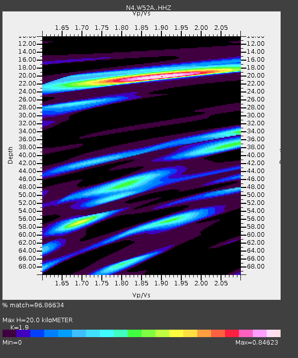
| Estimated Moho Depth: |
20.0 km |
| Estimated Crust Vp/Vs: |
1.90 |
| Assumed Crust Vp: |
6.35 km/s |
| Estimated Crust Vs: |
3.342 km/s |
| Estimated Crust Poisson's Ratio: |
0.31 |
|
| Radial Match: |
96.86634 % |
| Radial Bump: |
356 |
| Transverse Match: |
87.06193 % |
| Transverse Bump: |
400 |
| SOD ConfigId: |
7422571 |
| Insert Time: |
2019-04-19 23:33:08.679 +0000 |
| GWidth: |
2.5 |
| Max Bumps: |
400 |
| Tol: |
0.001 |
|

Signal To Noise
| Channel | StoN | STA | LTA |
| N4:W52A: :HHZ:20150727T04:59:23.230005Z | 18.488922 | 1.5762871E-6 | 8.5255756E-8 |
| N4:W52A: :HHN:20150727T04:59:23.230005Z | 11.546082 | 5.722189E-7 | 4.9559574E-8 |
| N4:W52A: :HHE:20150727T04:59:23.230005Z | 7.9981704 | 5.942177E-7 | 7.4294206E-8 |
| Arrivals |
| Ps | 3.0 SECOND |
| PpPs | 8.8 SECOND |
| PsPs/PpSs | 12 SECOND |


