You are here: Home > Network List > OV - Observatorio Vulcanolżgico y Sismolżgico de Costa Rica Stations List
> Station PLAN Los Planes de Bahía Drake , Puntarenas > Earthquake Result Viewer
PLAN Los Planes de Bahía Drake , Puntarenas - Earthquake Result Viewer
| Earthquake location: |
Fox Islands, Aleutian Islands |
| Earthquake latitude/longitude: |
52.4/-169.7 |
| Earthquake time(UTC): |
2015/07/27 (208) 04:49:44 GMT |
| Earthquake Depth: |
12 km |
| Earthquake Magnitude: |
6.9 MO |
| Earthquake Catalog/Contributor: |
NEIC PDE/NEIC ALERT |
|
| Network: |
OV Observatorio Vulcanolżgico y Sismolżgico de Costa Rica |
| Station: |
PLAN Los Planes de Bahía Drake , Puntarenas |
| Lat/Lon: |
8.67 N/83.68 W |
| Elevation: |
133 m |
|
| Distance: |
80.7 deg |
| Az: |
87.85 deg |
| Baz: |
321.713 deg |
| Ray Param: |
0.048065595 |
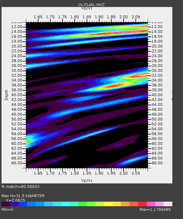
| Estimated Moho Depth: |
31.5 km |
| Estimated Crust Vp/Vs: |
2.09 |
| Assumed Crust Vp: |
6.436 km/s |
| Estimated Crust Vs: |
3.076 km/s |
| Estimated Crust Poisson's Ratio: |
0.35 |
|
| Radial Match: |
90.55843 % |
| Radial Bump: |
400 |
| Transverse Match: |
82.611694 % |
| Transverse Bump: |
400 |
| SOD ConfigId: |
7422571 |
| Insert Time: |
2019-04-19 23:34:34.151 +0000 |
| GWidth: |
2.5 |
| Max Bumps: |
400 |
| Tol: |
0.001 |
|

Signal To Noise
| Channel | StoN | STA | LTA |
| OV:PLAN: :HHZ:20150727T05:01:24.769983Z | 4.644141 | 1.0779552E-6 | 2.3211076E-7 |
| OV:PLAN: :HHN:20150727T05:01:24.769983Z | 1.92482 | 4.991474E-7 | 2.593216E-7 |
| OV:PLAN: :HHE:20150727T05:01:24.769983Z | 1.344953 | 3.354904E-7 | 2.4944399E-7 |
| Arrivals |
| Ps | 5.5 SECOND |
| PpPs | 15 SECOND |
| PsPs/PpSs | 20 SECOND |


