You are here: Home > Network List > TA - USArray Transportable Network (new EarthScope stations) Stations List
> Station F62A Pittston Farm, Pittston Academy Grant, ME, USA > Earthquake Result Viewer
F62A Pittston Farm, Pittston Academy Grant, ME, USA - Earthquake Result Viewer

| Earthquake location: |
Fox Islands, Aleutian Islands |
| Earthquake latitude/longitude: |
52.4/-169.7 |
| Earthquake time(UTC): |
2015/07/27 (208) 04:49:44 GMT |
| Earthquake Depth: |
12 km |
| Earthquake Magnitude: |
6.9 MO |
| Earthquake Catalog/Contributor: |
NEIC PDE/NEIC ALERT |
|
| Network: |
TA USArray Transportable Network (new EarthScope stations) |
| Station: |
F62A Pittston Farm, Pittston Academy Grant, ME, USA |
| Lat/Lon: |
45.90 N/69.97 W |
| Elevation: |
331 m |
|
| Distance: |
60.4 deg |
| Az: |
52.32 deg |
| Baz: |
315.993 deg |
| Ray Param: |
0.06152964 |
| Estimated Moho Depth: |
42.5 km |
| Estimated Crust Vp/Vs: |
1.62 |
| Assumed Crust Vp: |
6.419 km/s |
| Estimated Crust Vs: |
3.975 km/s |
| Estimated Crust Poisson's Ratio: |
0.19 |
|
| Radial Match: |
95.55744 % |
| Radial Bump: |
400 |
| Transverse Match: |
80.52967 % |
| Transverse Bump: |
400 |
| SOD ConfigId: |
7422571 |
| Insert Time: |
2019-04-19 23:36:02.034 +0000 |
| GWidth: |
2.5 |
| Max Bumps: |
400 |
| Tol: |
0.001 |
|
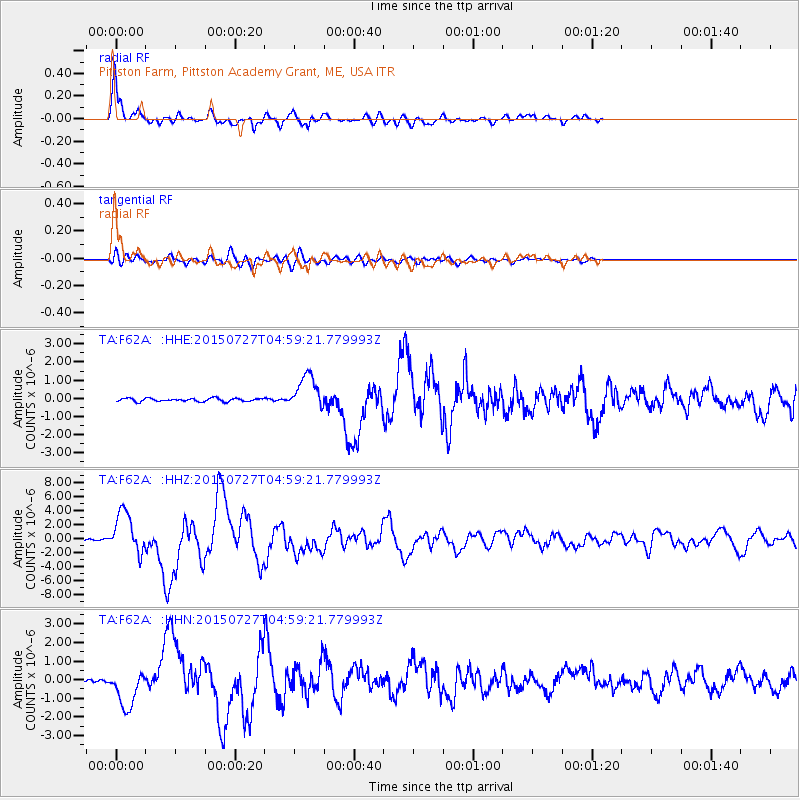
Signal To Noise
| Channel | StoN | STA | LTA |
| TA:F62A: :HHZ:20150727T04:59:21.779993Z | 41.04329 | 2.9328678E-6 | 7.145792E-8 |
| TA:F62A: :HHN:20150727T04:59:21.779993Z | 9.758109 | 1.0106709E-6 | 1.03572404E-7 |
| TA:F62A: :HHE:20150727T04:59:21.779993Z | 10.487315 | 9.363811E-7 | 8.928702E-8 |
| Arrivals |
| Ps | 4.3 SECOND |
| PpPs | 16 SECOND |
| PsPs/PpSs | 21 SECOND |


