You are here: Home > Network List > TA - USArray Transportable Network (new EarthScope stations) Stations List
> Station H59A Cadyville, NY, USA > Earthquake Result Viewer
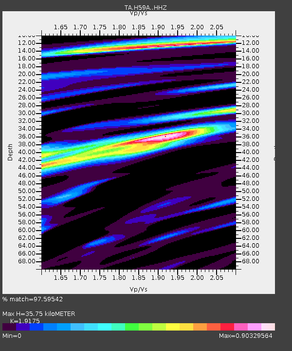
H59A Cadyville, NY, USA - Earthquake Result Viewer
| Earthquake location: |
Fox Islands, Aleutian Islands |
| Earthquake latitude/longitude: |
52.4/-169.7 |
| Earthquake time(UTC): |
2015/07/27 (208) 04:49:44 GMT |
| Earthquake Depth: |
12 km |
| Earthquake Magnitude: |
6.9 MO |
| Earthquake Catalog/Contributor: |
NEIC PDE/NEIC ALERT |
|
| Network: |
TA USArray Transportable Network (new EarthScope stations) |
| Station: |
H59A Cadyville, NY, USA |
| Lat/Lon: |
44.65 N/73.69 W |
| Elevation: |
355 m |
|
| Distance: |
59.5 deg |
| Az: |
55.499 deg |
| Baz: |
314.947 deg |
| Ray Param: |
0.06215423 |
| Estimated Moho Depth: |
35.75 km |
| Estimated Crust Vp/Vs: |
1.92 |
| Assumed Crust Vp: |
6.419 km/s |
| Estimated Crust Vs: |
3.348 km/s |
| Estimated Crust Poisson's Ratio: |
0.31 |
|
| Radial Match: |
97.59542 % |
| Radial Bump: |
293 |
| Transverse Match: |
91.71076 % |
| Transverse Bump: |
400 |
| SOD ConfigId: |
7422571 |
| Insert Time: |
2019-04-19 23:36:12.461 +0000 |
| GWidth: |
2.5 |
| Max Bumps: |
400 |
| Tol: |
0.001 |
|

Signal To Noise
| Channel | StoN | STA | LTA |
| TA:H59A: :HHZ:20150727T04:59:15.209985Z | 31.20695 | 2.7889657E-6 | 8.937002E-8 |
| TA:H59A: :HHN:20150727T04:59:15.209985Z | 10.808816 | 1.0052291E-6 | 9.300086E-8 |
| TA:H59A: :HHE:20150727T04:59:15.209985Z | 11.19771 | 8.855473E-7 | 7.9082895E-8 |
| Arrivals |
| Ps | 5.3 SECOND |
| PpPs | 16 SECOND |
| PsPs/PpSs | 21 SECOND |


