You are here: Home > Network List > TA - USArray Transportable Network (new EarthScope stations) Stations List
> Station H61A Lyndonville, VT, USA > Earthquake Result Viewer
H61A Lyndonville, VT, USA - Earthquake Result Viewer
| Earthquake location: |
Fox Islands, Aleutian Islands |
| Earthquake latitude/longitude: |
52.4/-169.7 |
| Earthquake time(UTC): |
2015/07/27 (208) 04:49:44 GMT |
| Earthquake Depth: |
12 km |
| Earthquake Magnitude: |
6.9 MO |
| Earthquake Catalog/Contributor: |
NEIC PDE/NEIC ALERT |
|
| Network: |
TA USArray Transportable Network (new EarthScope stations) |
| Station: |
H61A Lyndonville, VT, USA |
| Lat/Lon: |
44.53 N/71.93 W |
| Elevation: |
462 m |
|
| Distance: |
60.4 deg |
| Az: |
54.554 deg |
| Baz: |
315.708 deg |
| Ray Param: |
0.06152137 |
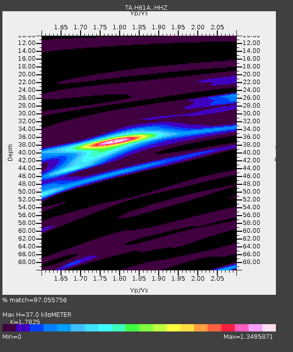
| Estimated Moho Depth: |
37.0 km |
| Estimated Crust Vp/Vs: |
1.78 |
| Assumed Crust Vp: |
6.419 km/s |
| Estimated Crust Vs: |
3.601 km/s |
| Estimated Crust Poisson's Ratio: |
0.27 |
|
| Radial Match: |
97.055756 % |
| Radial Bump: |
233 |
| Transverse Match: |
89.6418 % |
| Transverse Bump: |
400 |
| SOD ConfigId: |
7422571 |
| Insert Time: |
2019-04-19 23:36:12.977 +0000 |
| GWidth: |
2.5 |
| Max Bumps: |
400 |
| Tol: |
0.001 |
|

Signal To Noise
| Channel | StoN | STA | LTA |
| TA:H61A: :HHZ:20150727T04:59:21.880029Z | 23.914482 | 2.4748497E-6 | 1.03487494E-7 |
| TA:H61A: :HHN:20150727T04:59:21.880029Z | 15.763461 | 1.0500626E-6 | 6.661371E-8 |
| TA:H61A: :HHE:20150727T04:59:21.880029Z | 12.307371 | 8.754912E-7 | 7.113552E-8 |
| Arrivals |
| Ps | 4.7 SECOND |
| PpPs | 15 SECOND |
| PsPs/PpSs | 20 SECOND |


