You are here: Home > Network List > TA - USArray Transportable Network (new EarthScope stations) Stations List
> Station H65A Eastbrook, ME, USA > Earthquake Result Viewer
H65A Eastbrook, ME, USA - Earthquake Result Viewer
| Earthquake location: |
Fox Islands, Aleutian Islands |
| Earthquake latitude/longitude: |
52.4/-169.7 |
| Earthquake time(UTC): |
2015/07/27 (208) 04:49:44 GMT |
| Earthquake Depth: |
12 km |
| Earthquake Magnitude: |
6.9 MO |
| Earthquake Catalog/Contributor: |
NEIC PDE/NEIC ALERT |
|
| Network: |
TA USArray Transportable Network (new EarthScope stations) |
| Station: |
H65A Eastbrook, ME, USA |
| Lat/Lon: |
44.70 N/68.25 W |
| Elevation: |
98 m |
|
| Distance: |
62.1 deg |
| Az: |
52.255 deg |
| Baz: |
317.18 deg |
| Ray Param: |
0.06041799 |
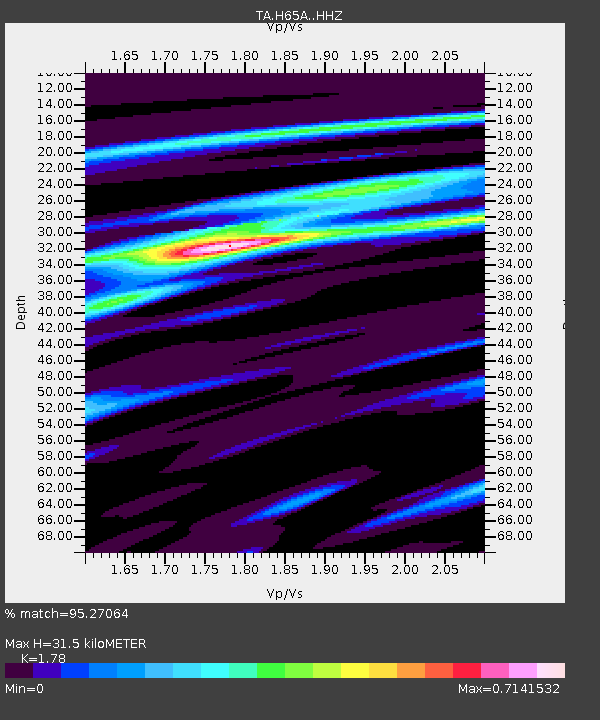
| Estimated Moho Depth: |
31.5 km |
| Estimated Crust Vp/Vs: |
1.78 |
| Assumed Crust Vp: |
6.419 km/s |
| Estimated Crust Vs: |
3.606 km/s |
| Estimated Crust Poisson's Ratio: |
0.27 |
|
| Radial Match: |
95.27064 % |
| Radial Bump: |
243 |
| Transverse Match: |
88.24574 % |
| Transverse Bump: |
400 |
| SOD ConfigId: |
7422571 |
| Insert Time: |
2019-04-19 23:36:16.413 +0000 |
| GWidth: |
2.5 |
| Max Bumps: |
400 |
| Tol: |
0.001 |
|

Signal To Noise
| Channel | StoN | STA | LTA |
| TA:H65A: :HHZ:20150727T04:59:33.300012Z | 29.8441 | 3.1256934E-6 | 1.0473404E-7 |
| TA:H65A: :HHN:20150727T04:59:33.300012Z | 10.548064 | 1.1367644E-6 | 1.0776995E-7 |
| TA:H65A: :HHE:20150727T04:59:33.300012Z | 10.87942 | 1.0738485E-6 | 9.870457E-8 |
| Arrivals |
| Ps | 4.0 SECOND |
| PpPs | 13 SECOND |
| PsPs/PpSs | 17 SECOND |


