You are here: Home > Network List > TA - USArray Transportable Network (new EarthScope stations) Stations List
> Station H66A Whiting, ME, USA > Earthquake Result Viewer
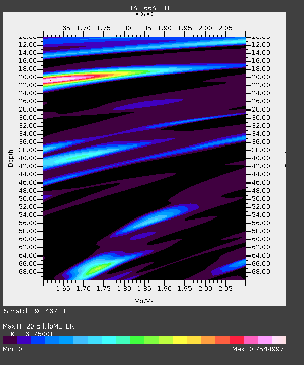
H66A Whiting, ME, USA - Earthquake Result Viewer
| Earthquake location: |
Fox Islands, Aleutian Islands |
| Earthquake latitude/longitude: |
52.4/-169.7 |
| Earthquake time(UTC): |
2015/07/27 (208) 04:49:44 GMT |
| Earthquake Depth: |
12 km |
| Earthquake Magnitude: |
6.9 MO |
| Earthquake Catalog/Contributor: |
NEIC PDE/NEIC ALERT |
|
| Network: |
TA USArray Transportable Network (new EarthScope stations) |
| Station: |
H66A Whiting, ME, USA |
| Lat/Lon: |
44.79 N/67.31 W |
| Elevation: |
55 m |
|
| Distance: |
62.5 deg |
| Az: |
51.633 deg |
| Baz: |
317.547 deg |
| Ray Param: |
0.060162704 |
| Estimated Moho Depth: |
20.5 km |
| Estimated Crust Vp/Vs: |
1.62 |
| Assumed Crust Vp: |
6.419 km/s |
| Estimated Crust Vs: |
3.969 km/s |
| Estimated Crust Poisson's Ratio: |
0.19 |
|
| Radial Match: |
91.46713 % |
| Radial Bump: |
277 |
| Transverse Match: |
83.392555 % |
| Transverse Bump: |
400 |
| SOD ConfigId: |
7422571 |
| Insert Time: |
2019-04-19 23:36:17.350 +0000 |
| GWidth: |
2.5 |
| Max Bumps: |
400 |
| Tol: |
0.001 |
|

Signal To Noise
| Channel | StoN | STA | LTA |
| TA:H66A: :HHZ:20150727T04:59:35.889978Z | 37.26691 | 3.0855483E-6 | 8.279593E-8 |
| TA:H66A: :HHN:20150727T04:59:35.889978Z | 13.461909 | 1.1685156E-6 | 8.680162E-8 |
| TA:H66A: :HHE:20150727T04:59:35.889978Z | 11.321872 | 1.0384135E-6 | 9.1717475E-8 |
| Arrivals |
| Ps | 2.1 SECOND |
| PpPs | 8.0 SECOND |
| PsPs/PpSs | 10 SECOND |


