You are here: Home > Network List > TA - USArray Transportable Network (new EarthScope stations) Stations List
> Station I60A Shoreham, VT, USA > Earthquake Result Viewer
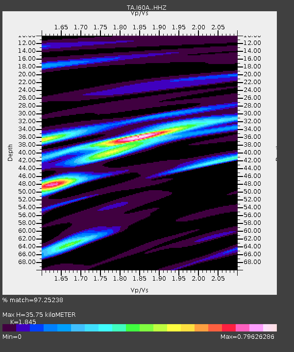
I60A Shoreham, VT, USA - Earthquake Result Viewer
| Earthquake location: |
Fox Islands, Aleutian Islands |
| Earthquake latitude/longitude: |
52.4/-169.7 |
| Earthquake time(UTC): |
2015/07/27 (208) 04:49:44 GMT |
| Earthquake Depth: |
12 km |
| Earthquake Magnitude: |
6.9 MO |
| Earthquake Catalog/Contributor: |
NEIC PDE/NEIC ALERT |
|
| Network: |
TA USArray Transportable Network (new EarthScope stations) |
| Station: |
I60A Shoreham, VT, USA |
| Lat/Lon: |
43.84 N/73.29 W |
| Elevation: |
101 m |
|
| Distance: |
60.3 deg |
| Az: |
55.916 deg |
| Baz: |
315.434 deg |
| Ray Param: |
0.061650045 |
| Estimated Moho Depth: |
35.75 km |
| Estimated Crust Vp/Vs: |
1.85 |
| Assumed Crust Vp: |
6.419 km/s |
| Estimated Crust Vs: |
3.479 km/s |
| Estimated Crust Poisson's Ratio: |
0.29 |
|
| Radial Match: |
97.25238 % |
| Radial Bump: |
231 |
| Transverse Match: |
90.09115 % |
| Transverse Bump: |
400 |
| SOD ConfigId: |
7422571 |
| Insert Time: |
2019-04-19 23:36:21.669 +0000 |
| GWidth: |
2.5 |
| Max Bumps: |
400 |
| Tol: |
0.001 |
|

Signal To Noise
| Channel | StoN | STA | LTA |
| TA:I60A: :HHZ:20150727T04:59:20.480005Z | 35.4808 | 2.6060338E-6 | 7.344912E-8 |
| TA:I60A: :HHN:20150727T04:59:20.480005Z | 22.792141 | 1.0596236E-6 | 4.6490744E-8 |
| TA:I60A: :HHE:20150727T04:59:20.480005Z | 17.429804 | 1.0438778E-6 | 5.989039E-8 |
| Arrivals |
| Ps | 4.9 SECOND |
| PpPs | 15 SECOND |
| PsPs/PpSs | 20 SECOND |


