You are here: Home > Network List > TA - USArray Transportable Network (new EarthScope stations) Stations List
> Station J63A Strafford, NH, USA > Earthquake Result Viewer
J63A Strafford, NH, USA - Earthquake Result Viewer
| Earthquake location: |
Fox Islands, Aleutian Islands |
| Earthquake latitude/longitude: |
52.4/-169.7 |
| Earthquake time(UTC): |
2015/07/27 (208) 04:49:44 GMT |
| Earthquake Depth: |
12 km |
| Earthquake Magnitude: |
6.9 MO |
| Earthquake Catalog/Contributor: |
NEIC PDE/NEIC ALERT |
|
| Network: |
TA USArray Transportable Network (new EarthScope stations) |
| Station: |
J63A Strafford, NH, USA |
| Lat/Lon: |
43.28 N/71.08 W |
| Elevation: |
142 m |
|
| Distance: |
61.8 deg |
| Az: |
55.042 deg |
| Baz: |
316.53 deg |
| Ray Param: |
0.0606538 |
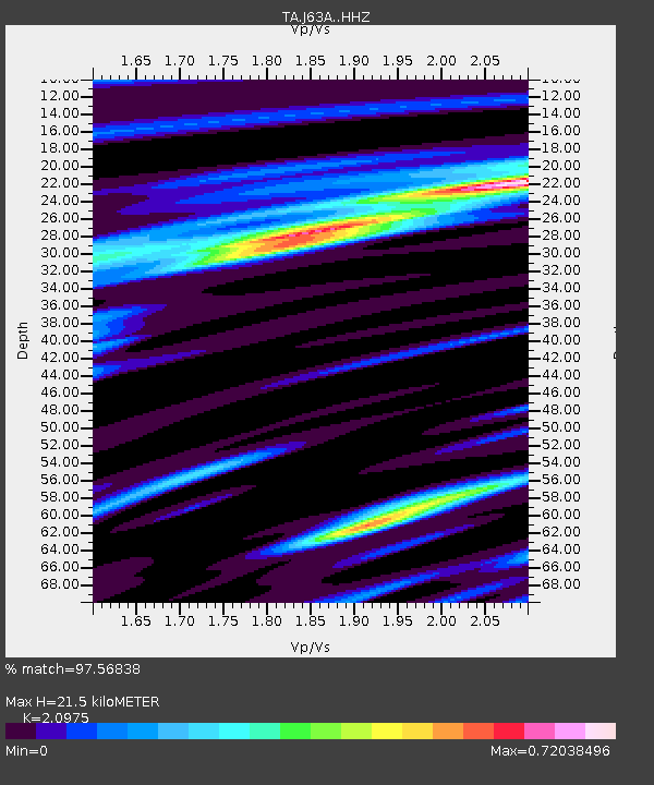
| Estimated Moho Depth: |
21.5 km |
| Estimated Crust Vp/Vs: |
2.10 |
| Assumed Crust Vp: |
6.419 km/s |
| Estimated Crust Vs: |
3.06 km/s |
| Estimated Crust Poisson's Ratio: |
0.35 |
|
| Radial Match: |
97.56838 % |
| Radial Bump: |
332 |
| Transverse Match: |
80.88531 % |
| Transverse Bump: |
400 |
| SOD ConfigId: |
7422571 |
| Insert Time: |
2019-04-19 23:36:32.149 +0000 |
| GWidth: |
2.5 |
| Max Bumps: |
400 |
| Tol: |
0.001 |
|

Signal To Noise
| Channel | StoN | STA | LTA |
| TA:J63A: :HHZ:20150727T04:59:30.819971Z | 20.921875 | 2.4811814E-6 | 1.18592695E-7 |
| TA:J63A: :HHN:20150727T04:59:30.819971Z | 12.50434 | 8.0406977E-7 | 6.430326E-8 |
| TA:J63A: :HHE:20150727T04:59:30.819971Z | 8.909064 | 7.790475E-7 | 8.744438E-8 |
| Arrivals |
| Ps | 3.8 SECOND |
| PpPs | 10.0 SECOND |
| PsPs/PpSs | 14 SECOND |


