You are here: Home > Network List > TA - USArray Transportable Network (new EarthScope stations) Stations List
> Station L04D Klamath Falls, OR, USA > Earthquake Result Viewer
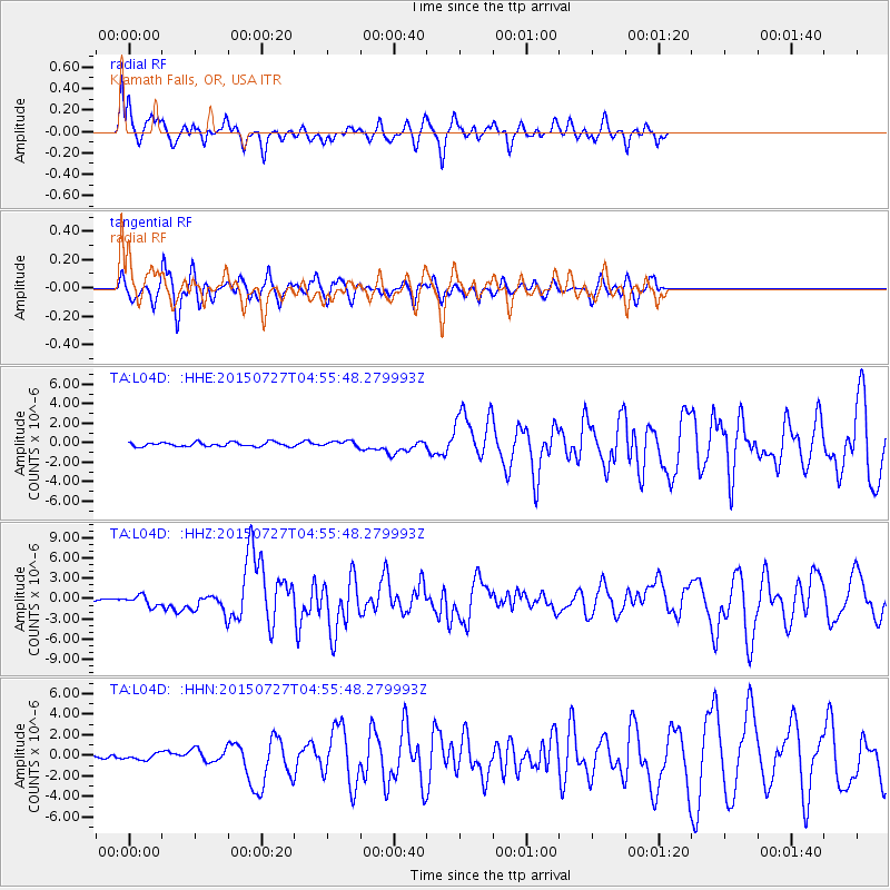
L04D Klamath Falls, OR, USA - Earthquake Result Viewer
*The percent match for this event was below the threshold and hence no stack was calculated.
| Earthquake location: |
Fox Islands, Aleutian Islands |
| Earthquake latitude/longitude: |
52.4/-169.7 |
| Earthquake time(UTC): |
2015/07/27 (208) 04:49:44 GMT |
| Earthquake Depth: |
12 km |
| Earthquake Magnitude: |
6.9 MO |
| Earthquake Catalog/Contributor: |
NEIC PDE/NEIC ALERT |
|
| Network: |
TA USArray Transportable Network (new EarthScope stations) |
| Station: |
L04D Klamath Falls, OR, USA |
| Lat/Lon: |
42.22 N/122.30 W |
| Elevation: |
1437 m |
|
| Distance: |
33.1 deg |
| Az: |
88.655 deg |
| Baz: |
304.406 deg |
| Ray Param: |
$rayparam |
*The percent match for this event was below the threshold and hence was not used in the summary stack. |
|
| Radial Match: |
66.900085 % |
| Radial Bump: |
375 |
| Transverse Match: |
77.09139 % |
| Transverse Bump: |
400 |
| SOD ConfigId: |
7422571 |
| Insert Time: |
2019-04-19 23:36:40.632 +0000 |
| GWidth: |
2.5 |
| Max Bumps: |
400 |
| Tol: |
0.001 |
|
Signal To Noise
| Channel | StoN | STA | LTA |
| TA:L04D: :HHZ:20150727T04:55:48.279993Z | 5.5733876 | 7.7739253E-7 | 1.3948295E-7 |
| TA:L04D: :HHN:20150727T04:55:48.279993Z | 1.2306538 | 2.8821302E-7 | 2.3419506E-7 |
| TA:L04D: :HHE:20150727T04:55:48.279993Z | 1.8240417 | 3.8793715E-7 | 2.1267999E-7 |
| Arrivals |
| Ps | |
| PpPs | |
| PsPs/PpSs | |


