You are here: Home > Network List > TA - USArray Transportable Network (new EarthScope stations) Stations List
> Station L63A North Scituate, RI, USA > Earthquake Result Viewer
L63A North Scituate, RI, USA - Earthquake Result Viewer
| Earthquake location: |
Fox Islands, Aleutian Islands |
| Earthquake latitude/longitude: |
52.4/-169.7 |
| Earthquake time(UTC): |
2015/07/27 (208) 04:49:44 GMT |
| Earthquake Depth: |
12 km |
| Earthquake Magnitude: |
6.9 MO |
| Earthquake Catalog/Contributor: |
NEIC PDE/NEIC ALERT |
|
| Network: |
TA USArray Transportable Network (new EarthScope stations) |
| Station: |
L63A North Scituate, RI, USA |
| Lat/Lon: |
41.86 N/71.61 W |
| Elevation: |
109 m |
|
| Distance: |
62.5 deg |
| Az: |
56.463 deg |
| Baz: |
316.836 deg |
| Ray Param: |
0.060155638 |
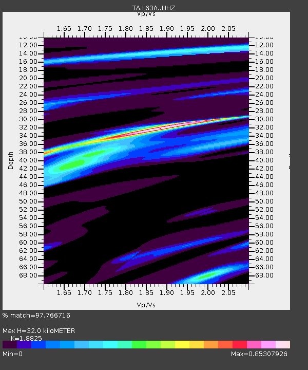
| Estimated Moho Depth: |
32.0 km |
| Estimated Crust Vp/Vs: |
1.88 |
| Assumed Crust Vp: |
6.472 km/s |
| Estimated Crust Vs: |
3.438 km/s |
| Estimated Crust Poisson's Ratio: |
0.30 |
|
| Radial Match: |
97.766716 % |
| Radial Bump: |
279 |
| Transverse Match: |
90.20011 % |
| Transverse Bump: |
400 |
| SOD ConfigId: |
7422571 |
| Insert Time: |
2019-04-19 23:36:42.762 +0000 |
| GWidth: |
2.5 |
| Max Bumps: |
400 |
| Tol: |
0.001 |
|

Signal To Noise
| Channel | StoN | STA | LTA |
| TA:L63A: :HHZ:20150727T04:59:35.889978Z | 23.13664 | 2.8243571E-6 | 1.220729E-7 |
| TA:L63A: :HHN:20150727T04:59:35.889978Z | 7.065289 | 8.7093264E-7 | 1.2326922E-7 |
| TA:L63A: :HHE:20150727T04:59:35.889978Z | 10.910694 | 9.927419E-7 | 9.098797E-8 |
| Arrivals |
| Ps | 4.6 SECOND |
| PpPs | 14 SECOND |
| PsPs/PpSs | 18 SECOND |


