You are here: Home > Network List > TA - USArray Transportable Network (new EarthScope stations) Stations List
> Station O03E Paynes Creek, CA, USA > Earthquake Result Viewer
O03E Paynes Creek, CA, USA - Earthquake Result Viewer
| Earthquake location: |
Fox Islands, Aleutian Islands |
| Earthquake latitude/longitude: |
52.4/-169.7 |
| Earthquake time(UTC): |
2015/07/27 (208) 04:49:44 GMT |
| Earthquake Depth: |
12 km |
| Earthquake Magnitude: |
6.9 MO |
| Earthquake Catalog/Contributor: |
NEIC PDE/NEIC ALERT |
|
| Network: |
TA USArray Transportable Network (new EarthScope stations) |
| Station: |
O03E Paynes Creek, CA, USA |
| Lat/Lon: |
40.29 N/121.80 W |
| Elevation: |
967 m |
|
| Distance: |
34.6 deg |
| Az: |
91.066 deg |
| Baz: |
306.739 deg |
| Ray Param: |
0.077676006 |
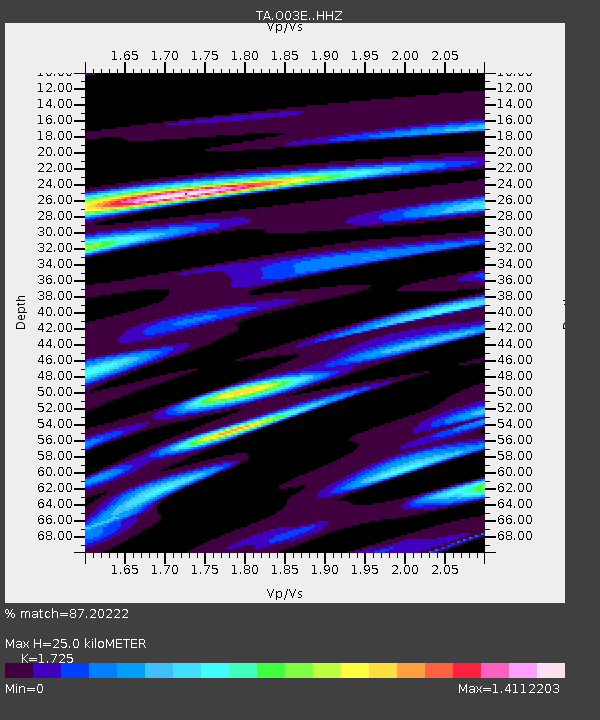
| Estimated Moho Depth: |
25.0 km |
| Estimated Crust Vp/Vs: |
1.73 |
| Assumed Crust Vp: |
6.566 km/s |
| Estimated Crust Vs: |
3.806 km/s |
| Estimated Crust Poisson's Ratio: |
0.25 |
|
| Radial Match: |
87.20222 % |
| Radial Bump: |
400 |
| Transverse Match: |
79.47677 % |
| Transverse Bump: |
400 |
| SOD ConfigId: |
7422571 |
| Insert Time: |
2019-04-19 23:36:56.184 +0000 |
| GWidth: |
2.5 |
| Max Bumps: |
400 |
| Tol: |
0.001 |
|
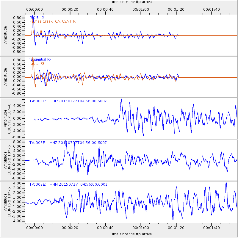
Signal To Noise
| Channel | StoN | STA | LTA |
| TA:O03E: :HHZ:20150727T04:56:00.600Z | 7.5546093 | 7.573678E-7 | 1.00252414E-7 |
| TA:O03E: :HHN:20150727T04:56:00.600Z | 1.9783654 | 3.4063314E-7 | 1.7217907E-7 |
| TA:O03E: :HHE:20150727T04:56:00.600Z | 2.7988315 | 4.962744E-7 | 1.7731487E-7 |
| Arrivals |
| Ps | 3.0 SECOND |
| PpPs | 9.5 SECOND |
| PsPs/PpSs | 13 SECOND |


