You are here: Home > Network List > TA - USArray Transportable Network (new EarthScope stations) Stations List
> Station Q24A Divide, CO, USA > Earthquake Result Viewer
Q24A Divide, CO, USA - Earthquake Result Viewer

| Earthquake location: |
Fox Islands, Aleutian Islands |
| Earthquake latitude/longitude: |
52.4/-169.7 |
| Earthquake time(UTC): |
2015/07/27 (208) 04:49:44 GMT |
| Earthquake Depth: |
12 km |
| Earthquake Magnitude: |
6.9 MO |
| Earthquake Catalog/Contributor: |
NEIC PDE/NEIC ALERT |
|
| Network: |
TA USArray Transportable Network (new EarthScope stations) |
| Station: |
Q24A Divide, CO, USA |
| Lat/Lon: |
38.96 N/105.15 W |
| Elevation: |
2775 m |
|
| Distance: |
45.5 deg |
| Az: |
80.413 deg |
| Baz: |
309.161 deg |
| Ray Param: |
0.07120913 |
| Estimated Moho Depth: |
44.25 km |
| Estimated Crust Vp/Vs: |
2.10 |
| Assumed Crust Vp: |
6.159 km/s |
| Estimated Crust Vs: |
2.94 km/s |
| Estimated Crust Poisson's Ratio: |
0.35 |
|
| Radial Match: |
94.25927 % |
| Radial Bump: |
318 |
| Transverse Match: |
87.45638 % |
| Transverse Bump: |
400 |
| SOD ConfigId: |
7422571 |
| Insert Time: |
2019-04-19 23:37:01.913 +0000 |
| GWidth: |
2.5 |
| Max Bumps: |
400 |
| Tol: |
0.001 |
|
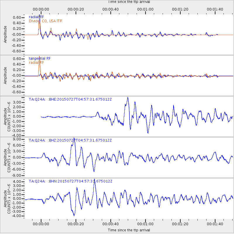
Signal To Noise
| Channel | StoN | STA | LTA |
| TA:Q24A: :BHZ:20150727T04:57:31.675012Z | 23.22285 | 1.0448472E-6 | 4.4992202E-8 |
| TA:Q24A: :BHN:20150727T04:57:31.675012Z | 9.355398 | 4.0981075E-7 | 4.3804736E-8 |
| TA:Q24A: :BHE:20150727T04:57:31.675012Z | 6.9547048 | 4.1974982E-7 | 6.03548E-8 |
| Arrivals |
| Ps | 8.3 SECOND |
| PpPs | 21 SECOND |
| PsPs/PpSs | 29 SECOND |


