You are here: Home > Network List > TA - USArray Transportable Network (new EarthScope stations) Stations List
> Station TPFO Pinon Flats, CA, USA > Earthquake Result Viewer
TPFO Pinon Flats, CA, USA - Earthquake Result Viewer
| Earthquake location: |
Fox Islands, Aleutian Islands |
| Earthquake latitude/longitude: |
52.4/-169.7 |
| Earthquake time(UTC): |
2015/07/27 (208) 04:49:44 GMT |
| Earthquake Depth: |
12 km |
| Earthquake Magnitude: |
6.9 MO |
| Earthquake Catalog/Contributor: |
NEIC PDE/NEIC ALERT |
|
| Network: |
TA USArray Transportable Network (new EarthScope stations) |
| Station: |
TPFO Pinon Flats, CA, USA |
| Lat/Lon: |
33.61 N/116.45 W |
| Elevation: |
1275 m |
|
| Distance: |
42.1 deg |
| Az: |
94.892 deg |
| Baz: |
312.955 deg |
| Ray Param: |
0.07335031 |
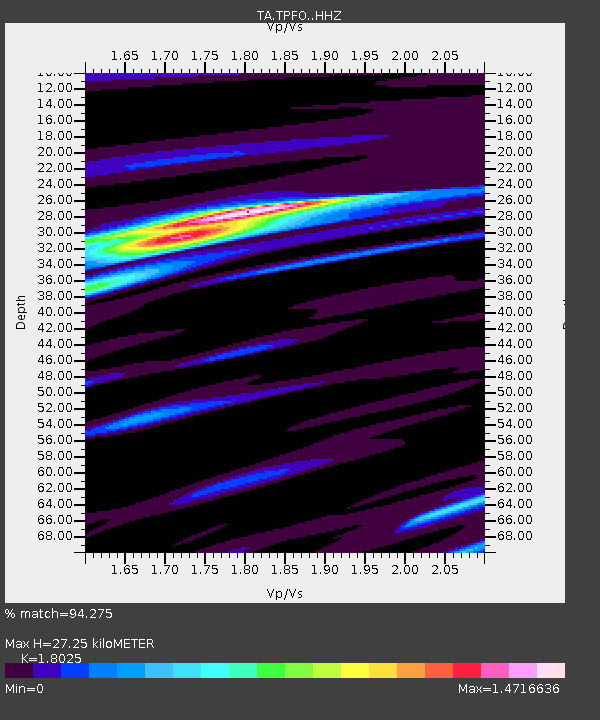
| Estimated Moho Depth: |
27.25 km |
| Estimated Crust Vp/Vs: |
1.80 |
| Assumed Crust Vp: |
6.264 km/s |
| Estimated Crust Vs: |
3.475 km/s |
| Estimated Crust Poisson's Ratio: |
0.28 |
|
| Radial Match: |
94.275 % |
| Radial Bump: |
215 |
| Transverse Match: |
86.43981 % |
| Transverse Bump: |
400 |
| SOD ConfigId: |
7422571 |
| Insert Time: |
2019-04-19 23:37:08.671 +0000 |
| GWidth: |
2.5 |
| Max Bumps: |
400 |
| Tol: |
0.001 |
|
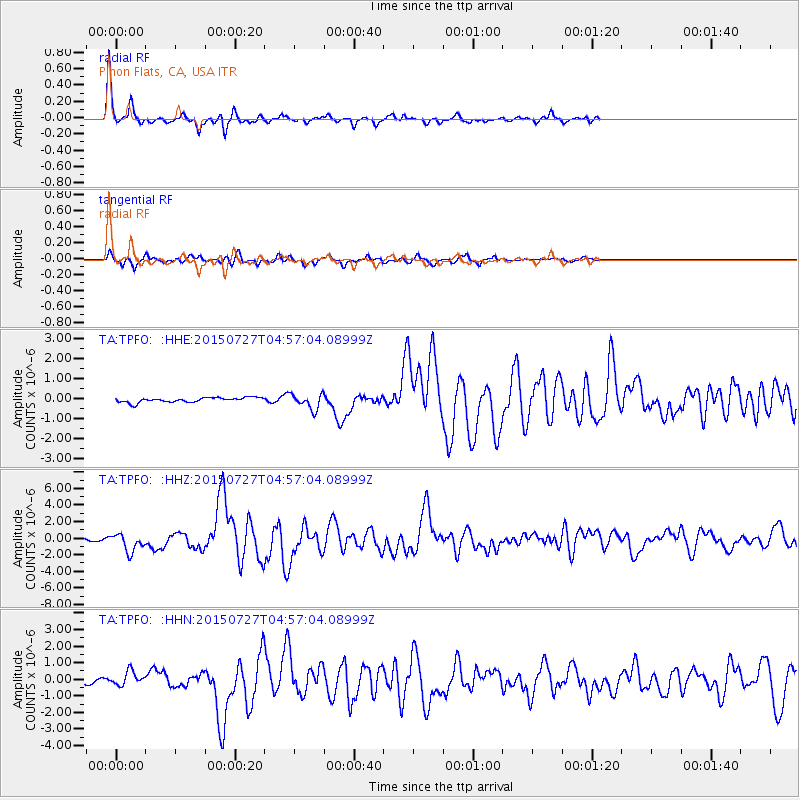
Signal To Noise
| Channel | StoN | STA | LTA |
| TA:TPFO: :HHZ:20150727T04:57:04.08999Z | 8.682005 | 1.0962137E-6 | 1.2626275E-7 |
| TA:TPFO: :HHN:20150727T04:57:04.08999Z | 3.2210474 | 4.3161313E-7 | 1.3399776E-7 |
| TA:TPFO: :HHE:20150727T04:57:04.08999Z | 3.0515227 | 3.6391162E-7 | 1.1925574E-7 |
| Arrivals |
| Ps | 3.7 SECOND |
| PpPs | 11 SECOND |
| PsPs/PpSs | 15 SECOND |


