You are here: Home > Network List > US - United States National Seismic Network Stations List
> Station OGNE Ogallala, Nebraska, USA > Earthquake Result Viewer
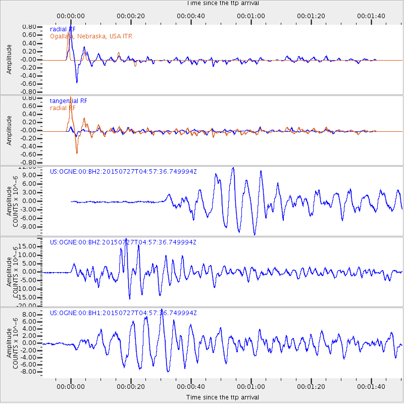
OGNE Ogallala, Nebraska, USA - Earthquake Result Viewer
| Earthquake location: |
Fox Islands, Aleutian Islands |
| Earthquake latitude/longitude: |
52.4/-169.7 |
| Earthquake time(UTC): |
2015/07/27 (208) 04:49:44 GMT |
| Earthquake Depth: |
12 km |
| Earthquake Magnitude: |
6.9 MO |
| Earthquake Catalog/Contributor: |
NEIC PDE/NEIC ALERT |
|
| Network: |
US United States National Seismic Network |
| Station: |
OGNE Ogallala, Nebraska, USA |
| Lat/Lon: |
40.95 N/102.03 W |
| Elevation: |
1054 m |
|
| Distance: |
46.2 deg |
| Az: |
76.174 deg |
| Baz: |
308.201 deg |
| Ray Param: |
0.0708063 |
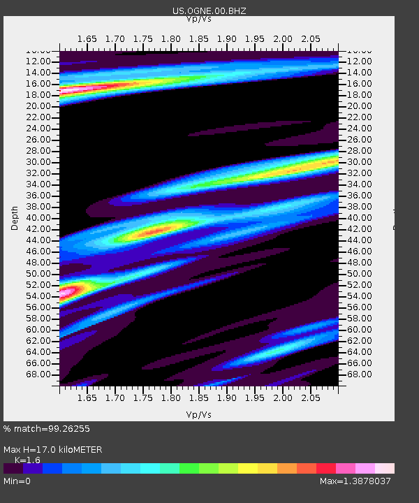
| Estimated Moho Depth: |
17.0 km |
| Estimated Crust Vp/Vs: |
1.60 |
| Assumed Crust Vp: |
6.483 km/s |
| Estimated Crust Vs: |
4.052 km/s |
| Estimated Crust Poisson's Ratio: |
0.18 |
|
| Radial Match: |
99.26255 % |
| Radial Bump: |
223 |
| Transverse Match: |
96.16273 % |
| Transverse Bump: |
282 |
| SOD ConfigId: |
7422571 |
| Insert Time: |
2019-04-19 23:38:19.807 +0000 |
| GWidth: |
2.5 |
| Max Bumps: |
400 |
| Tol: |
0.001 |
|
Signal To Noise
| Channel | StoN | STA | LTA |
| US:OGNE:00:BHZ:20150727T04:57:36.749994Z | 22.810867 | 2.388847E-6 | 1.0472407E-7 |
| US:OGNE:00:BH1:20150727T04:57:36.749994Z | 4.994688 | 7.934196E-7 | 1.5885267E-7 |
| US:OGNE:00:BH2:20150727T04:57:36.749994Z | 11.0733595 | 1.3790475E-6 | 1.2453742E-7 |
| Arrivals |
| Ps | 1.7 SECOND |
| PpPs | 6.3 SECOND |
| PsPs/PpSs | 8.0 SECOND |


