You are here: Home > Network List > UW - Pacific Northwest Regional Seismic Network Stations List
> Station WOLL Wollman Farm, Schrag, WA, USA > Earthquake Result Viewer
WOLL Wollman Farm, Schrag, WA, USA - Earthquake Result Viewer

| Earthquake location: |
Fox Islands, Aleutian Islands |
| Earthquake latitude/longitude: |
52.4/-169.7 |
| Earthquake time(UTC): |
2015/07/27 (208) 04:49:44 GMT |
| Earthquake Depth: |
12 km |
| Earthquake Magnitude: |
6.9 MO |
| Earthquake Catalog/Contributor: |
NEIC PDE/NEIC ALERT |
|
| Network: |
UW Pacific Northwest Regional Seismic Network |
| Station: |
WOLL Wollman Farm, Schrag, WA, USA |
| Lat/Lon: |
47.06 N/118.92 W |
| Elevation: |
385 m |
|
| Distance: |
32.7 deg |
| Az: |
78.728 deg |
| Baz: |
298.437 deg |
| Ray Param: |
0.07854994 |
| Estimated Moho Depth: |
29.0 km |
| Estimated Crust Vp/Vs: |
1.81 |
| Assumed Crust Vp: |
6.419 km/s |
| Estimated Crust Vs: |
3.542 km/s |
| Estimated Crust Poisson's Ratio: |
0.28 |
|
| Radial Match: |
95.13621 % |
| Radial Bump: |
365 |
| Transverse Match: |
89.16316 % |
| Transverse Bump: |
400 |
| SOD ConfigId: |
7422571 |
| Insert Time: |
2019-04-19 23:38:44.356 +0000 |
| GWidth: |
2.5 |
| Max Bumps: |
400 |
| Tol: |
0.001 |
|
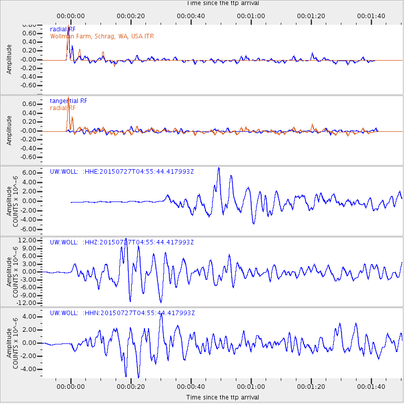
Signal To Noise
| Channel | StoN | STA | LTA |
| UW:WOLL: :HHZ:20150727T04:55:44.417993Z | 13.537349 | 1.7031742E-6 | 1.2581297E-7 |
| UW:WOLL: :HHN:20150727T04:55:44.417993Z | 7.947106 | 5.0272877E-7 | 6.325936E-8 |
| UW:WOLL: :HHE:20150727T04:55:44.417993Z | 9.473191 | 6.4907766E-7 | 6.8517316E-8 |
| Arrivals |
| Ps | 4.0 SECOND |
| PpPs | 12 SECOND |
| PsPs/PpSs | 16 SECOND |


