You are here: Home > Network List > X812 - Deep Structure of Three Continental Sutures in Eastern North America Stations List
> Station QM34 Ferme Vifranc, St-Pamphile, Quebec, Canada > Earthquake Result Viewer
QM34 Ferme Vifranc, St-Pamphile, Quebec, Canada - Earthquake Result Viewer
| Earthquake location: |
Fox Islands, Aleutian Islands |
| Earthquake latitude/longitude: |
52.4/-169.7 |
| Earthquake time(UTC): |
2015/07/27 (208) 04:49:44 GMT |
| Earthquake Depth: |
12 km |
| Earthquake Magnitude: |
6.9 MO |
| Earthquake Catalog/Contributor: |
NEIC PDE/NEIC ALERT |
|
| Network: |
X8 Deep Structure of Three Continental Sutures in Eastern North America |
| Station: |
QM34 Ferme Vifranc, St-Pamphile, Quebec, Canada |
| Lat/Lon: |
47.02 N/69.83 W |
| Elevation: |
374 m |
|
| Distance: |
59.7 deg |
| Az: |
51.338 deg |
| Baz: |
315.6 deg |
| Ray Param: |
0.062015135 |
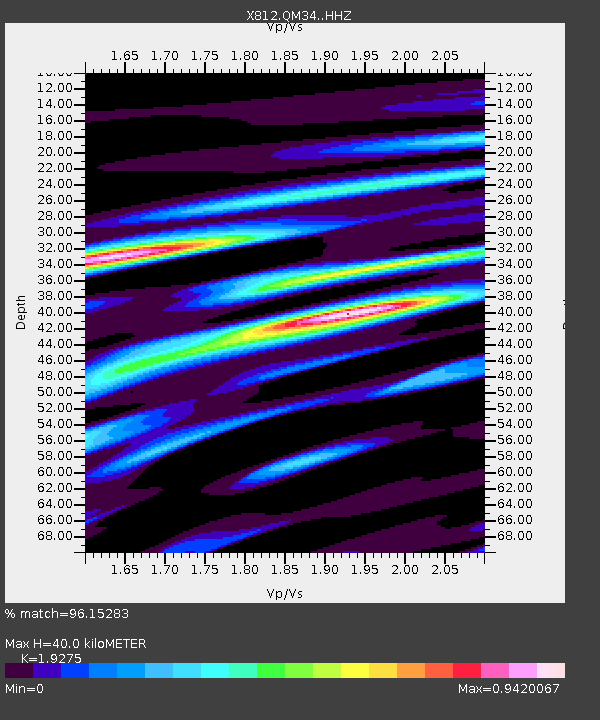
| Estimated Moho Depth: |
40.0 km |
| Estimated Crust Vp/Vs: |
1.93 |
| Assumed Crust Vp: |
6.419 km/s |
| Estimated Crust Vs: |
3.33 km/s |
| Estimated Crust Poisson's Ratio: |
0.32 |
|
| Radial Match: |
96.15283 % |
| Radial Bump: |
378 |
| Transverse Match: |
79.06326 % |
| Transverse Bump: |
400 |
| SOD ConfigId: |
7422571 |
| Insert Time: |
2019-04-19 23:39:13.915 +0000 |
| GWidth: |
2.5 |
| Max Bumps: |
400 |
| Tol: |
0.001 |
|
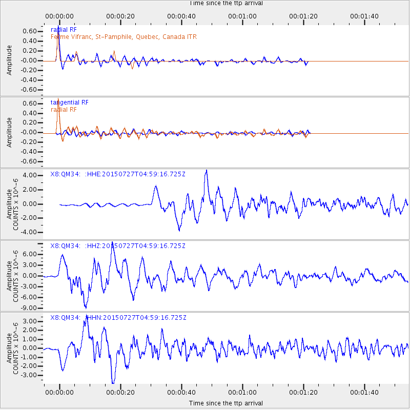
Signal To Noise
| Channel | StoN | STA | LTA |
| X8:QM34: :HHZ:20150727T04:59:16.725Z | 31.4583 | 3.3400252E-6 | 1.061731E-7 |
| X8:QM34: :HHN:20150727T04:59:16.725Z | 14.615404 | 1.1900573E-6 | 8.1424865E-8 |
| X8:QM34: :HHE:20150727T04:59:16.725Z | 9.00366 | 1.2628714E-6 | 1.40262E-7 |
| Arrivals |
| Ps | 6.0 SECOND |
| PpPs | 17 SECOND |
| PsPs/PpSs | 24 SECOND |


