You are here: Home > Network List > XD14 - Illuminating the architecture of the greater Mount St. Helens magmatic systems f Stations List
> Station MB05 "Mount St Helens, WA" > Earthquake Result Viewer
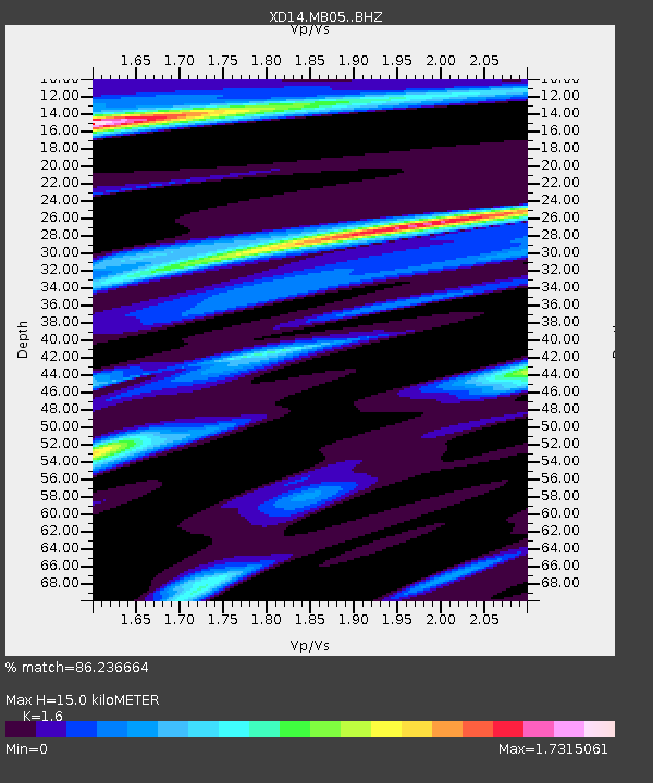
MB05 "Mount St Helens, WA" - Earthquake Result Viewer
| Earthquake location: |
Fox Islands, Aleutian Islands |
| Earthquake latitude/longitude: |
52.4/-169.7 |
| Earthquake time(UTC): |
2015/07/27 (208) 04:49:44 GMT |
| Earthquake Depth: |
12 km |
| Earthquake Magnitude: |
6.9 MO |
| Earthquake Catalog/Contributor: |
NEIC PDE/NEIC ALERT |
|
| Network: |
XD Illuminating the architecture of the greater Mount St. Helens magmatic systems f |
| Station: |
MB05 "Mount St Helens, WA" |
| Lat/Lon: |
46.62 N/122.28 W |
| Elevation: |
641 m |
|
| Distance: |
30.8 deg |
| Az: |
81.542 deg |
| Baz: |
298.387 deg |
| Ray Param: |
0.079222254 |
| Estimated Moho Depth: |
15.0 km |
| Estimated Crust Vp/Vs: |
1.60 |
| Assumed Crust Vp: |
6.566 km/s |
| Estimated Crust Vs: |
4.104 km/s |
| Estimated Crust Poisson's Ratio: |
0.18 |
|
| Radial Match: |
86.236664 % |
| Radial Bump: |
335 |
| Transverse Match: |
53.264786 % |
| Transverse Bump: |
400 |
| SOD ConfigId: |
7422571 |
| Insert Time: |
2019-04-19 23:39:18.598 +0000 |
| GWidth: |
2.5 |
| Max Bumps: |
400 |
| Tol: |
0.001 |
|

Signal To Noise
| Channel | StoN | STA | LTA |
| XD:MB05: :BHZ:20150727T04:55:28.415002Z | 9.103815 | 1.3944527E-6 | 1.5317235E-7 |
| XD:MB05: :BHN:20150727T04:55:28.415002Z | 2.12966 | 3.197838E-7 | 1.5015722E-7 |
| XD:MB05: :BHE:20150727T04:55:28.415002Z | 3.0901263 | 5.731033E-7 | 1.8546274E-7 |
| Arrivals |
| Ps | 1.5 SECOND |
| PpPs | 5.4 SECOND |
| PsPs/PpSs | 6.9 SECOND |


