You are here: Home > Network List > XD14 - Illuminating the architecture of the greater Mount St. Helens magmatic systems f Stations List
> Station MD12 "Mount St Helens, WA" > Earthquake Result Viewer
MD12 "Mount St Helens, WA" - Earthquake Result Viewer
| Earthquake location: |
Fox Islands, Aleutian Islands |
| Earthquake latitude/longitude: |
52.4/-169.7 |
| Earthquake time(UTC): |
2015/07/27 (208) 04:49:44 GMT |
| Earthquake Depth: |
12 km |
| Earthquake Magnitude: |
6.9 MO |
| Earthquake Catalog/Contributor: |
NEIC PDE/NEIC ALERT |
|
| Network: |
XD Illuminating the architecture of the greater Mount St. Helens magmatic systems f |
| Station: |
MD12 "Mount St Helens, WA" |
| Lat/Lon: |
46.48 N/121.22 W |
| Elevation: |
1496 m |
|
| Distance: |
31.6 deg |
| Az: |
81.111 deg |
| Baz: |
298.785 deg |
| Ray Param: |
0.07902194 |
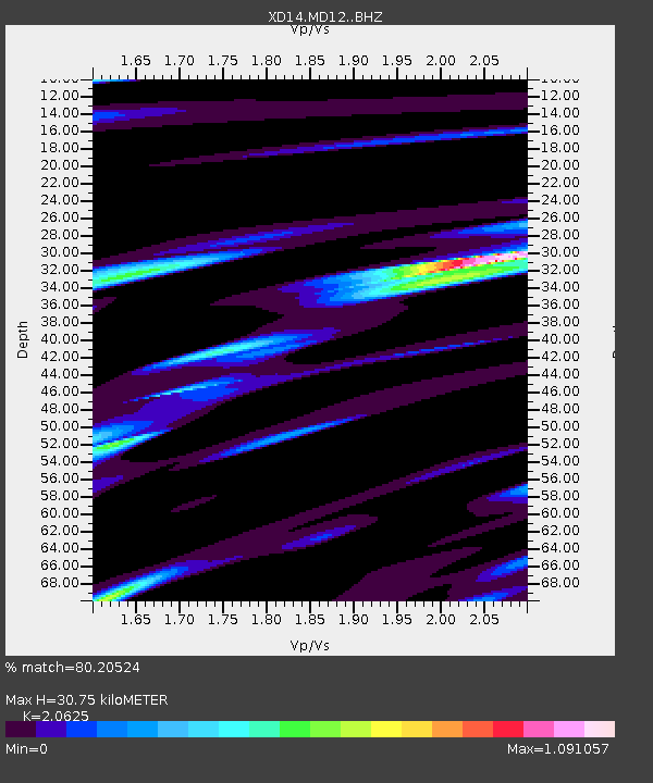
| Estimated Moho Depth: |
30.75 km |
| Estimated Crust Vp/Vs: |
2.06 |
| Assumed Crust Vp: |
6.597 km/s |
| Estimated Crust Vs: |
3.199 km/s |
| Estimated Crust Poisson's Ratio: |
0.35 |
|
| Radial Match: |
80.20524 % |
| Radial Bump: |
400 |
| Transverse Match: |
65.54105 % |
| Transverse Bump: |
400 |
| SOD ConfigId: |
7422571 |
| Insert Time: |
2019-04-19 23:39:22.853 +0000 |
| GWidth: |
2.5 |
| Max Bumps: |
400 |
| Tol: |
0.001 |
|

Signal To Noise
| Channel | StoN | STA | LTA |
| XD:MD12: :BHZ:20150727T04:55:34.665002Z | 13.258026 | 1.1800358E-6 | 8.900539E-8 |
| XD:MD12: :BHN:20150727T04:55:34.665002Z | 1.1057376 | 3.0418144E-7 | 2.750937E-7 |
| XD:MD12: :BHE:20150727T04:55:34.665002Z | 3.6810038 | 6.057467E-7 | 1.645602E-7 |
| Arrivals |
| Ps | 5.3 SECOND |
| PpPs | 13 SECOND |
| PsPs/PpSs | 19 SECOND |


