You are here: Home > Network List > XD14 - Illuminating the architecture of the greater Mount St. Helens magmatic systems f Stations List
> Station MJ03 "Mount St Helens, WA" > Earthquake Result Viewer
MJ03 "Mount St Helens, WA" - Earthquake Result Viewer
| Earthquake location: |
Fox Islands, Aleutian Islands |
| Earthquake latitude/longitude: |
52.4/-169.7 |
| Earthquake time(UTC): |
2015/07/27 (208) 04:49:44 GMT |
| Earthquake Depth: |
12 km |
| Earthquake Magnitude: |
6.9 MO |
| Earthquake Catalog/Contributor: |
NEIC PDE/NEIC ALERT |
|
| Network: |
XD Illuminating the architecture of the greater Mount St. Helens magmatic systems f |
| Station: |
MJ03 "Mount St Helens, WA" |
| Lat/Lon: |
46.16 N/122.56 W |
| Elevation: |
397 m |
|
| Distance: |
30.9 deg |
| Az: |
82.516 deg |
| Baz: |
299.017 deg |
| Ray Param: |
0.07920926 |
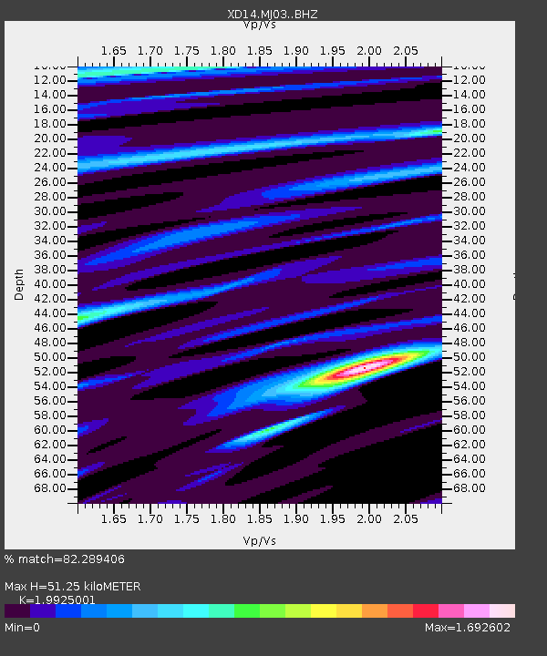
| Estimated Moho Depth: |
51.25 km |
| Estimated Crust Vp/Vs: |
1.99 |
| Assumed Crust Vp: |
6.566 km/s |
| Estimated Crust Vs: |
3.295 km/s |
| Estimated Crust Poisson's Ratio: |
0.33 |
|
| Radial Match: |
82.289406 % |
| Radial Bump: |
400 |
| Transverse Match: |
54.245075 % |
| Transverse Bump: |
400 |
| SOD ConfigId: |
7422571 |
| Insert Time: |
2019-04-19 23:39:44.007 +0000 |
| GWidth: |
2.5 |
| Max Bumps: |
400 |
| Tol: |
0.001 |
|

Signal To Noise
| Channel | StoN | STA | LTA |
| XD:MJ03: :BHZ:20150727T04:55:28.825006Z | 5.3189406 | 8.380249E-7 | 1.5755485E-7 |
| XD:MJ03: :BHN:20150727T04:55:28.825006Z | 3.2915895 | 2.3616795E-7 | 7.174891E-8 |
| XD:MJ03: :BHE:20150727T04:55:28.825006Z | 6.5003877 | 5.1167785E-7 | 7.8714976E-8 |
| Arrivals |
| Ps | 8.3 SECOND |
| PpPs | 22 SECOND |
| PsPs/PpSs | 30 SECOND |


