You are here: Home > Network List > XD14 - Illuminating the architecture of the greater Mount St. Helens magmatic systems f Stations List
> Station MK10 "Mount St Helens, WA" > Earthquake Result Viewer
MK10 "Mount St Helens, WA" - Earthquake Result Viewer
| Earthquake location: |
Fox Islands, Aleutian Islands |
| Earthquake latitude/longitude: |
52.4/-169.7 |
| Earthquake time(UTC): |
2015/07/27 (208) 04:49:44 GMT |
| Earthquake Depth: |
12 km |
| Earthquake Magnitude: |
6.9 MO |
| Earthquake Catalog/Contributor: |
NEIC PDE/NEIC ALERT |
|
| Network: |
XD Illuminating the architecture of the greater Mount St. Helens magmatic systems f |
| Station: |
MK10 "Mount St Helens, WA" |
| Lat/Lon: |
46.14 N/121.77 W |
| Elevation: |
1186 m |
|
| Distance: |
31.4 deg |
| Az: |
82.022 deg |
| Baz: |
299.165 deg |
| Ray Param: |
0.07908077 |
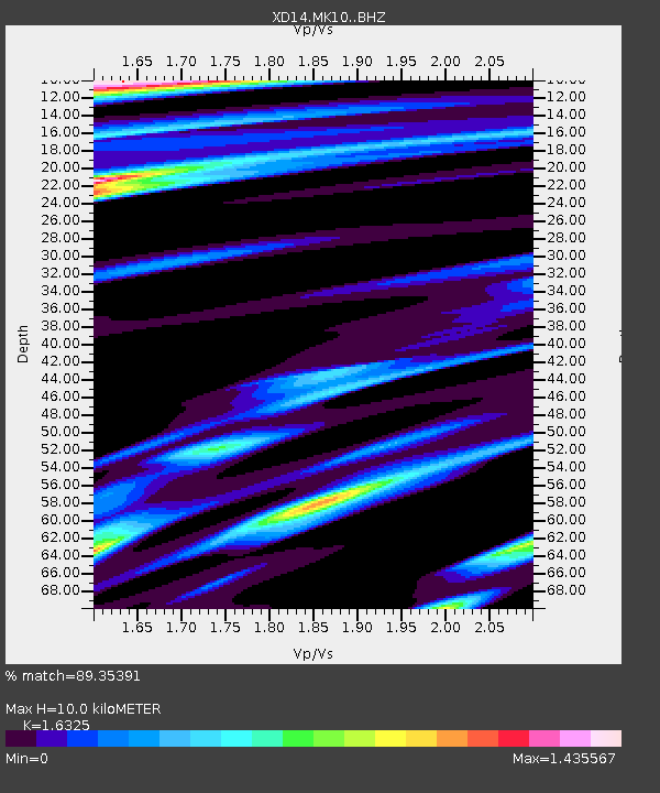
| Estimated Moho Depth: |
10.0 km |
| Estimated Crust Vp/Vs: |
1.63 |
| Assumed Crust Vp: |
6.597 km/s |
| Estimated Crust Vs: |
4.041 km/s |
| Estimated Crust Poisson's Ratio: |
0.20 |
|
| Radial Match: |
89.35391 % |
| Radial Bump: |
324 |
| Transverse Match: |
66.18077 % |
| Transverse Bump: |
400 |
| SOD ConfigId: |
7422571 |
| Insert Time: |
2019-04-19 23:39:49.357 +0000 |
| GWidth: |
2.5 |
| Max Bumps: |
400 |
| Tol: |
0.001 |
|

Signal To Noise
| Channel | StoN | STA | LTA |
| XD:MK10: :BHZ:20150727T04:55:33.135004Z | 10.694394 | 1.2448127E-6 | 1.1639862E-7 |
| XD:MK10: :BHN:20150727T04:55:33.135004Z | 1.5576516 | 4.2146343E-7 | 2.7057615E-7 |
| XD:MK10: :BHE:20150727T04:55:33.135004Z | 3.4423246 | 8.1410644E-7 | 2.3649903E-7 |
| Arrivals |
| Ps | 1.1 SECOND |
| PpPs | 3.6 SECOND |
| PsPs/PpSs | 4.7 SECOND |


