You are here: Home > Network List > XD14 - Illuminating the architecture of the greater Mount St. Helens magmatic systems f Stations List
> Station MG10 "Mount St Helens, WA" > Earthquake Result Viewer
MG10 "Mount St Helens, WA" - Earthquake Result Viewer
| Earthquake location: |
Fox Islands, Aleutian Islands |
| Earthquake latitude/longitude: |
52.8/-169.6 |
| Earthquake time(UTC): |
2015/07/27 (208) 04:51:22 GMT |
| Earthquake Depth: |
32 km |
| Earthquake Magnitude: |
5.9 MB |
| Earthquake Catalog/Contributor: |
NEIC PDE/NEIC COMCAT |
|
| Network: |
XD Illuminating the architecture of the greater Mount St. Helens magmatic systems f |
| Station: |
MG10 "Mount St Helens, WA" |
| Lat/Lon: |
46.34 N/121.66 W |
| Elevation: |
893 m |
|
| Distance: |
31.3 deg |
| Az: |
82.325 deg |
| Baz: |
299.657 deg |
| Ray Param: |
0.07908887 |
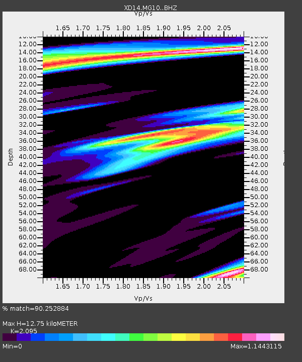
| Estimated Moho Depth: |
12.75 km |
| Estimated Crust Vp/Vs: |
2.10 |
| Assumed Crust Vp: |
6.597 km/s |
| Estimated Crust Vs: |
3.149 km/s |
| Estimated Crust Poisson's Ratio: |
0.35 |
|
| Radial Match: |
90.252884 % |
| Radial Bump: |
297 |
| Transverse Match: |
65.94372 % |
| Transverse Bump: |
400 |
| SOD ConfigId: |
7422571 |
| Insert Time: |
2019-04-19 23:48:27.774 +0000 |
| GWidth: |
2.5 |
| Max Bumps: |
400 |
| Tol: |
0.001 |
|

Signal To Noise
| Channel | StoN | STA | LTA |
| XD:MG10: :BHZ:20150727T04:57:08.115012Z | 1.347798 | 6.3532116E-6 | 4.7137714E-6 |
| XD:MG10: :BHN:20150727T04:57:08.115012Z | 1.5221493 | 5.1031598E-6 | 3.3526012E-6 |
| XD:MG10: :BHE:20150727T04:57:08.115012Z | 1.2916138 | 6.140953E-6 | 4.7544804E-6 |
| Arrivals |
| Ps | 2.3 SECOND |
| PpPs | 5.6 SECOND |
| PsPs/PpSs | 7.8 SECOND |


