You are here: Home > Network List > XD14 - Illuminating the architecture of the greater Mount St. Helens magmatic systems f Stations List
> Station MK04 "Mount St Helens, WA" > Earthquake Result Viewer
MK04 "Mount St Helens, WA" - Earthquake Result Viewer
| Earthquake location: |
Fox Islands, Aleutian Islands |
| Earthquake latitude/longitude: |
52.8/-169.6 |
| Earthquake time(UTC): |
2015/07/27 (208) 04:51:22 GMT |
| Earthquake Depth: |
32 km |
| Earthquake Magnitude: |
5.9 MB |
| Earthquake Catalog/Contributor: |
NEIC PDE/NEIC COMCAT |
|
| Network: |
XD Illuminating the architecture of the greater Mount St. Helens magmatic systems f |
| Station: |
MK04 "Mount St Helens, WA" |
| Lat/Lon: |
46.11 N/122.39 W |
| Elevation: |
482 m |
|
| Distance: |
30.9 deg |
| Az: |
83.204 deg |
| Baz: |
299.882 deg |
| Ray Param: |
0.07917456 |
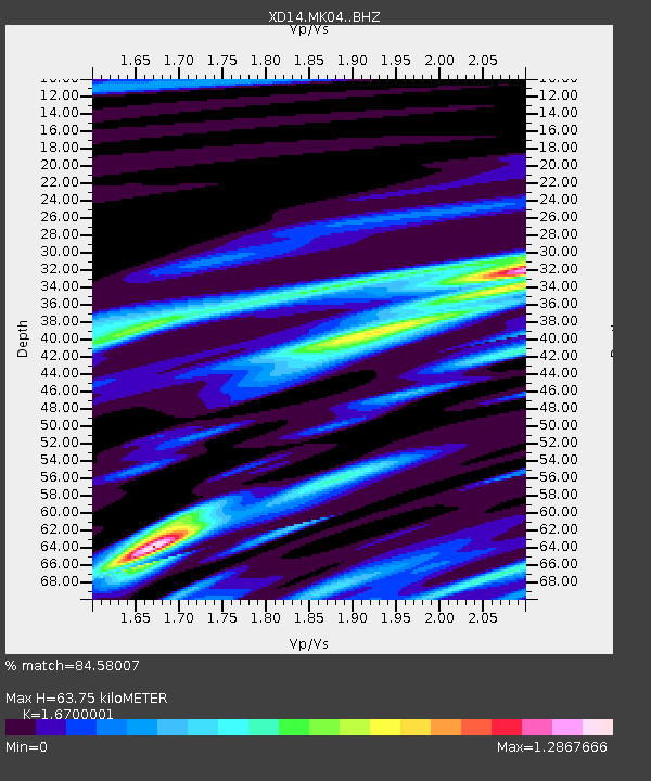
| Estimated Moho Depth: |
63.75 km |
| Estimated Crust Vp/Vs: |
1.67 |
| Assumed Crust Vp: |
6.566 km/s |
| Estimated Crust Vs: |
3.932 km/s |
| Estimated Crust Poisson's Ratio: |
0.22 |
|
| Radial Match: |
84.58007 % |
| Radial Bump: |
308 |
| Transverse Match: |
73.77803 % |
| Transverse Bump: |
400 |
| SOD ConfigId: |
7422571 |
| Insert Time: |
2019-04-19 23:48:31.880 +0000 |
| GWidth: |
2.5 |
| Max Bumps: |
400 |
| Tol: |
0.001 |
|

Signal To Noise
| Channel | StoN | STA | LTA |
| XD:MK04: :BHZ:20150727T04:57:05.224998Z | 1.5527108 | 6.312922E-6 | 4.0657424E-6 |
| XD:MK04: :BHN:20150727T04:57:05.224998Z | 0.72302485 | 1.7552229E-6 | 2.4276108E-6 |
| XD:MK04: :BHE:20150727T04:57:05.224998Z | 0.9524825 | 5.1831803E-6 | 5.441759E-6 |
| Arrivals |
| Ps | 7.1 SECOND |
| PpPs | 24 SECOND |
| PsPs/PpSs | 31 SECOND |


