You are here: Home > Network List > TA - USArray Transportable Network (new EarthScope stations) Stations List
> Station X43A Marvell, AR, USA > Earthquake Result Viewer
X43A Marvell, AR, USA - Earthquake Result Viewer
*The percent match for this event was below the threshold and hence no stack was calculated.
| Earthquake location: |
Fox Islands, Aleutian Islands |
| Earthquake latitude/longitude: |
52.2/-169.5 |
| Earthquake time(UTC): |
2015/07/27 (208) 04:55:45 GMT |
| Earthquake Depth: |
21 km |
| Earthquake Magnitude: |
6.7 MS |
| Earthquake Catalog/Contributor: |
NEIC PDE/NEIC ALERT |
|
| Network: |
TA USArray Transportable Network (new EarthScope stations) |
| Station: |
X43A Marvell, AR, USA |
| Lat/Lon: |
34.52 N/90.88 W |
| Elevation: |
53 m |
|
| Distance: |
57.0 deg |
| Az: |
74.838 deg |
| Baz: |
313.93 deg |
| Ray Param: |
$rayparam |
*The percent match for this event was below the threshold and hence was not used in the summary stack. |
|
| Radial Match: |
65.4372 % |
| Radial Bump: |
400 |
| Transverse Match: |
65.369896 % |
| Transverse Bump: |
400 |
| SOD ConfigId: |
7422571 |
| Insert Time: |
2019-04-19 23:55:01.130 +0000 |
| GWidth: |
2.5 |
| Max Bumps: |
400 |
| Tol: |
0.001 |
|
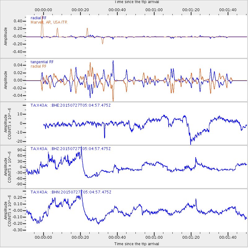
Signal To Noise
| Channel | StoN | STA | LTA |
| TA:X43A: :BHZ:20150727T05:04:57.475Z | 2.1023126 | 4.60468E-5 | 2.190293E-5 |
| TA:X43A: :BHN:20150727T05:04:57.475Z | 1.3941563 | 1.0111441E-7 | 7.252731E-8 |
| TA:X43A: :BHE:20150727T05:04:57.475Z | 2.0451705 | 3.3899898E-6 | 1.6575585E-6 |
| Arrivals |
| Ps | |
| PpPs | |
| PsPs/PpSs | |


