You are here: Home > Network List > UU - University of Utah Regional Network Stations List
> Station CCUT Cedar City, UT, USA > Earthquake Result Viewer
CCUT Cedar City, UT, USA - Earthquake Result Viewer

| Earthquake location: |
Northern Chile |
| Earthquake latitude/longitude: |
-18.4/-69.4 |
| Earthquake time(UTC): |
2015/03/23 (082) 04:51:37 GMT |
| Earthquake Depth: |
128 km |
| Earthquake Magnitude: |
6.1 MWP, 6.1 MO |
| Earthquake Catalog/Contributor: |
NEIC PDE/NEIC ALERT |
|
| Network: |
UU University of Utah Regional Network |
| Station: |
CCUT Cedar City, UT, USA |
| Lat/Lon: |
37.55 N/113.36 W |
| Elevation: |
2127 m |
|
| Distance: |
69.4 deg |
| Az: |
323.854 deg |
| Baz: |
135.21 deg |
| Ray Param: |
0.05533693 |
| Estimated Moho Depth: |
10.5 km |
| Estimated Crust Vp/Vs: |
2.10 |
| Assumed Crust Vp: |
6.194 km/s |
| Estimated Crust Vs: |
2.953 km/s |
| Estimated Crust Poisson's Ratio: |
0.35 |
|
| Radial Match: |
95.86357 % |
| Radial Bump: |
368 |
| Transverse Match: |
86.39056 % |
| Transverse Bump: |
400 |
| SOD ConfigId: |
872571 |
| Insert Time: |
2015-04-06 05:13:36.466 +0000 |
| GWidth: |
2.5 |
| Max Bumps: |
400 |
| Tol: |
0.001 |
|
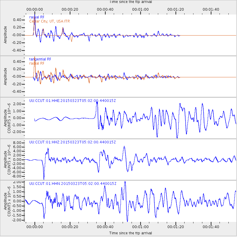
Signal To Noise
| Channel | StoN | STA | LTA |
| UU:CCUT:01:HHZ:20150323T05:02:00.440015Z | 4.525053 | 6.808428E-7 | 1.5046074E-7 |
| UU:CCUT:01:HHN:20150323T05:02:00.440015Z | 1.5882447 | 2.1762277E-7 | 1.3702093E-7 |
| UU:CCUT:01:HHE:20150323T05:02:00.440015Z | 1.6594504 | 2.3589172E-7 | 1.421505E-7 |
| Arrivals |
| Ps | 1.9 SECOND |
| PpPs | 5.1 SECOND |
| PsPs/PpSs | 7.0 SECOND |


