You are here: Home > Network List > TA - USArray Transportable Network (new EarthScope stations) Stations List
> Station X43A Marvell, AR, USA > Earthquake Result Viewer
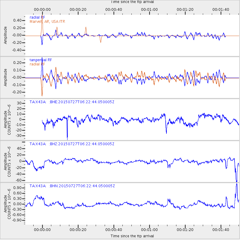
X43A Marvell, AR, USA - Earthquake Result Viewer
*The percent match for this event was below the threshold and hence no stack was calculated.
| Earthquake location: |
Fox Islands, Aleutian Islands |
| Earthquake latitude/longitude: |
52.3/-169.3 |
| Earthquake time(UTC): |
2015/07/27 (208) 06:13:33 GMT |
| Earthquake Depth: |
32 km |
| Earthquake Magnitude: |
5.1 mb |
| Earthquake Catalog/Contributor: |
ISC/ISC |
|
| Network: |
TA USArray Transportable Network (new EarthScope stations) |
| Station: |
X43A Marvell, AR, USA |
| Lat/Lon: |
34.52 N/90.88 W |
| Elevation: |
53 m |
|
| Distance: |
56.8 deg |
| Az: |
75.082 deg |
| Baz: |
314.036 deg |
| Ray Param: |
$rayparam |
*The percent match for this event was below the threshold and hence was not used in the summary stack. |
|
| Radial Match: |
59.4343 % |
| Radial Bump: |
400 |
| Transverse Match: |
60.96975 % |
| Transverse Bump: |
400 |
| SOD ConfigId: |
7422571 |
| Insert Time: |
2019-04-20 00:10:11.949 +0000 |
| GWidth: |
2.5 |
| Max Bumps: |
400 |
| Tol: |
0.001 |
|
Signal To Noise
| Channel | StoN | STA | LTA |
| TA:X43A: :BHZ:20150727T06:22:44.050005Z | 2.0886402 | 1.26417335E-5 | 6.0526145E-6 |
| TA:X43A: :BHN:20150727T06:22:44.050005Z | 2.8895502 | 2.51473E-7 | 8.7028425E-8 |
| TA:X43A: :BHE:20150727T06:22:44.050005Z | 1.1174144 | 6.496357E-6 | 5.8137402E-6 |
| Arrivals |
| Ps | |
| PpPs | |
| PsPs/PpSs | |


