You are here: Home > Network List > TA - USArray Transportable Network (new EarthScope stations) Stations List
> Station 121A Cookes Peak, Deming, NM, USA > Earthquake Result Viewer
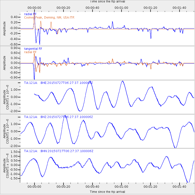
121A Cookes Peak, Deming, NM, USA - Earthquake Result Viewer
*The percent match for this event was below the threshold and hence no stack was calculated.
| Earthquake location: |
Fox Islands, Aleutian Islands |
| Earthquake latitude/longitude: |
52.2/-169.2 |
| Earthquake time(UTC): |
2015/07/27 (208) 06:19:31 GMT |
| Earthquake Depth: |
21 km |
| Earthquake Magnitude: |
5.0 mb |
| Earthquake Catalog/Contributor: |
ISC/ISC |
|
| Network: |
TA USArray Transportable Network (new EarthScope stations) |
| Station: |
121A Cookes Peak, Deming, NM, USA |
| Lat/Lon: |
32.53 N/107.79 W |
| Elevation: |
1652 m |
|
| Distance: |
47.9 deg |
| Az: |
89.126 deg |
| Baz: |
313.237 deg |
| Ray Param: |
$rayparam |
*The percent match for this event was below the threshold and hence was not used in the summary stack. |
|
| Radial Match: |
69.61124 % |
| Radial Bump: |
400 |
| Transverse Match: |
54.355747 % |
| Transverse Bump: |
391 |
| SOD ConfigId: |
7422571 |
| Insert Time: |
2019-04-20 00:17:28.380 +0000 |
| GWidth: |
2.5 |
| Max Bumps: |
400 |
| Tol: |
0.001 |
|
Signal To Noise
| Channel | StoN | STA | LTA |
| TA:121A: :BHZ:20150727T06:27:37.100006Z | 2.218553 | 1.0508702E-6 | 4.7367368E-7 |
| TA:121A: :BHN:20150727T06:27:37.100006Z | 0.9838871 | 6.607979E-7 | 6.7161966E-7 |
| TA:121A: :BHE:20150727T06:27:37.100006Z | 2.779329 | 1.6061759E-6 | 5.779006E-7 |
| Arrivals |
| Ps | |
| PpPs | |
| PsPs/PpSs | |


