You are here: Home > Network List > TA - USArray Transportable Network (new EarthScope stations) Stations List
> Station D62A Allapoint, Allagash, ME, USA > Earthquake Result Viewer
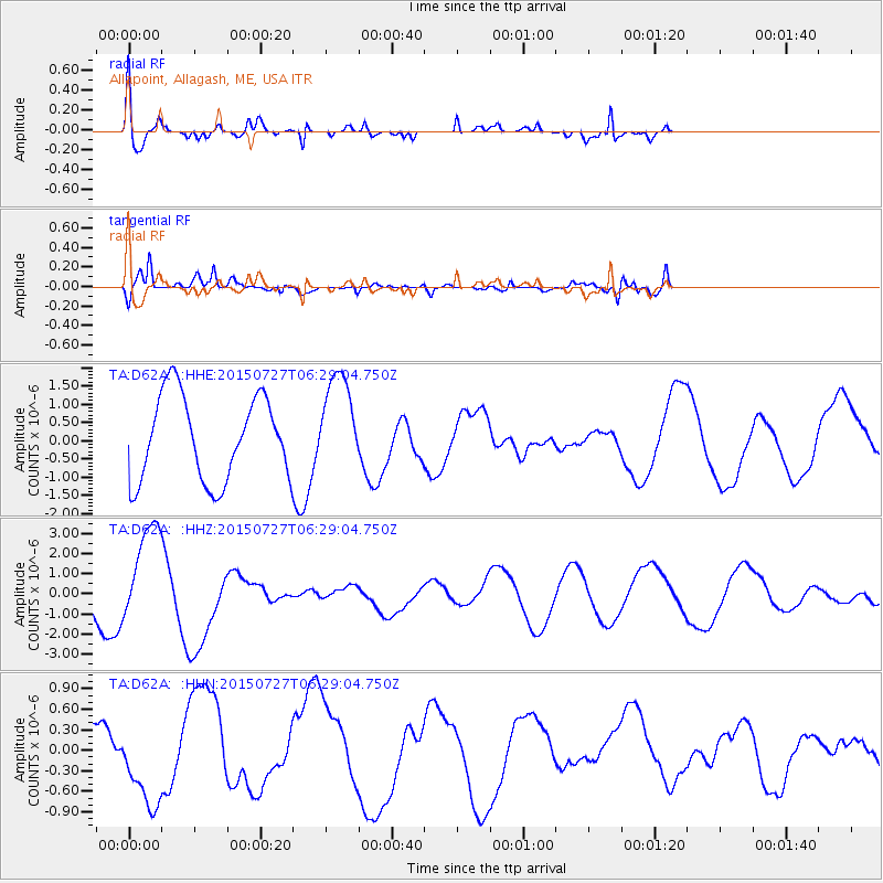
D62A Allapoint, Allagash, ME, USA - Earthquake Result Viewer
*The percent match for this event was below the threshold and hence no stack was calculated.
| Earthquake location: |
Fox Islands, Aleutian Islands |
| Earthquake latitude/longitude: |
52.2/-169.2 |
| Earthquake time(UTC): |
2015/07/27 (208) 06:19:31 GMT |
| Earthquake Depth: |
21 km |
| Earthquake Magnitude: |
5.0 mb |
| Earthquake Catalog/Contributor: |
ISC/ISC |
|
| Network: |
TA USArray Transportable Network (new EarthScope stations) |
| Station: |
D62A Allapoint, Allagash, ME, USA |
| Lat/Lon: |
47.08 N/69.05 W |
| Elevation: |
189 m |
|
| Distance: |
59.9 deg |
| Az: |
51.001 deg |
| Baz: |
315.58 deg |
| Ray Param: |
$rayparam |
*The percent match for this event was below the threshold and hence was not used in the summary stack. |
|
| Radial Match: |
54.61565 % |
| Radial Bump: |
400 |
| Transverse Match: |
74.385155 % |
| Transverse Bump: |
400 |
| SOD ConfigId: |
7422571 |
| Insert Time: |
2019-04-20 00:17:29.594 +0000 |
| GWidth: |
2.5 |
| Max Bumps: |
400 |
| Tol: |
0.001 |
|
Signal To Noise
| Channel | StoN | STA | LTA |
| TA:D62A: :HHZ:20150727T06:29:04.750Z | 2.7710216 | 2.5424445E-6 | 9.1751156E-7 |
| TA:D62A: :HHN:20150727T06:29:04.750Z | 1.0462078 | 5.8176147E-7 | 5.560668E-7 |
| TA:D62A: :HHE:20150727T06:29:04.750Z | 1.1670809 | 1.344948E-6 | 1.1524035E-6 |
| Arrivals |
| Ps | |
| PpPs | |
| PsPs/PpSs | |


