You are here: Home > Network List > TA - USArray Transportable Network (new EarthScope stations) Stations List
> Station KMSC Kings Mountain, Blacksburg, SC, USA > Earthquake Result Viewer
KMSC Kings Mountain, Blacksburg, SC, USA - Earthquake Result Viewer

| Earthquake location: |
Fox Islands, Aleutian Islands |
| Earthquake latitude/longitude: |
52.3/-169.3 |
| Earthquake time(UTC): |
2015/07/27 (208) 07:40:31 GMT |
| Earthquake Depth: |
31 km |
| Earthquake Magnitude: |
5.6 MB, 5.0 ML, 5.6 MI |
| Earthquake Catalog/Contributor: |
NEIC PDE/NEIC COMCAT |
|
| Network: |
TA USArray Transportable Network (new EarthScope stations) |
| Station: |
KMSC Kings Mountain, Blacksburg, SC, USA |
| Lat/Lon: |
35.14 N/81.33 W |
| Elevation: |
240 m |
|
| Distance: |
62.0 deg |
| Az: |
68.118 deg |
| Baz: |
315.97 deg |
| Ray Param: |
0.06049262 |
| Estimated Moho Depth: |
33.5 km |
| Estimated Crust Vp/Vs: |
2.03 |
| Assumed Crust Vp: |
6.419 km/s |
| Estimated Crust Vs: |
3.166 km/s |
| Estimated Crust Poisson's Ratio: |
0.34 |
|
| Radial Match: |
81.67586 % |
| Radial Bump: |
400 |
| Transverse Match: |
63.816082 % |
| Transverse Bump: |
400 |
| SOD ConfigId: |
7422571 |
| Insert Time: |
2019-04-20 00:33:14.609 +0000 |
| GWidth: |
2.5 |
| Max Bumps: |
400 |
| Tol: |
0.001 |
|
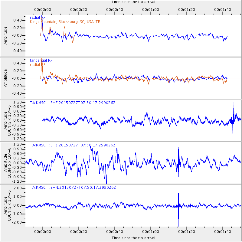
Signal To Noise
| Channel | StoN | STA | LTA |
| TA:KMSC: :BHZ:20150727T07:50:17.299026Z | 1.6886566 | 3.063405E-7 | 1.8141077E-7 |
| TA:KMSC: :BHN:20150727T07:50:17.299026Z | 1.9463384 | 1.8811404E-7 | 9.6650226E-8 |
| TA:KMSC: :BHE:20150727T07:50:17.299026Z | 2.015313 | 2.728399E-7 | 1.353834E-7 |
| Arrivals |
| Ps | 5.6 SECOND |
| PpPs | 15 SECOND |
| PsPs/PpSs | 21 SECOND |


