You are here: Home > Network List > TA - USArray Transportable Network (new EarthScope stations) Stations List
> Station X43A Marvell, AR, USA > Earthquake Result Viewer
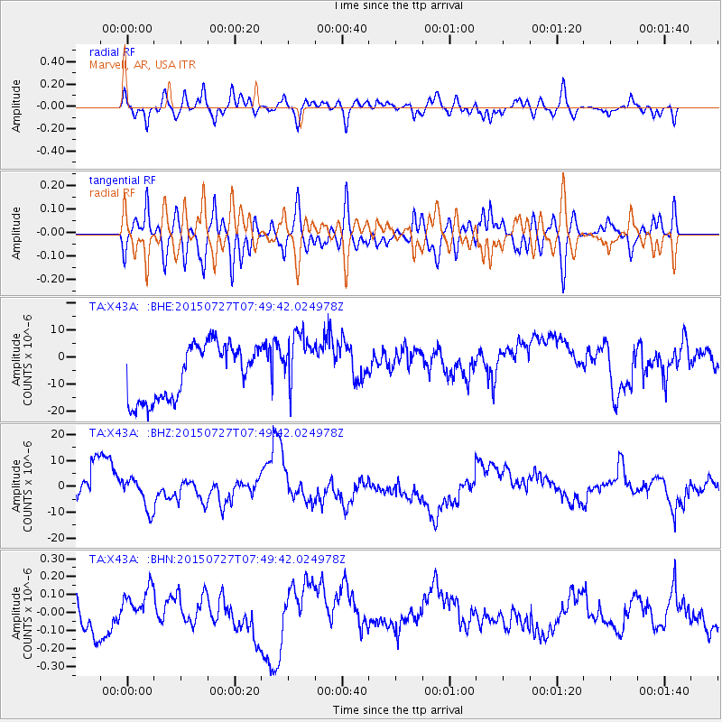
X43A Marvell, AR, USA - Earthquake Result Viewer
*The percent match for this event was below the threshold and hence no stack was calculated.
| Earthquake location: |
Fox Islands, Aleutian Islands |
| Earthquake latitude/longitude: |
52.3/-169.3 |
| Earthquake time(UTC): |
2015/07/27 (208) 07:40:31 GMT |
| Earthquake Depth: |
31 km |
| Earthquake Magnitude: |
5.6 MB, 5.0 ML, 5.6 MI |
| Earthquake Catalog/Contributor: |
NEIC PDE/NEIC COMCAT |
|
| Network: |
TA USArray Transportable Network (new EarthScope stations) |
| Station: |
X43A Marvell, AR, USA |
| Lat/Lon: |
34.52 N/90.88 W |
| Elevation: |
53 m |
|
| Distance: |
56.8 deg |
| Az: |
75.08 deg |
| Baz: |
314.083 deg |
| Ray Param: |
$rayparam |
*The percent match for this event was below the threshold and hence was not used in the summary stack. |
|
| Radial Match: |
36.307747 % |
| Radial Bump: |
400 |
| Transverse Match: |
36.247852 % |
| Transverse Bump: |
400 |
| SOD ConfigId: |
7422571 |
| Insert Time: |
2019-04-20 00:33:23.489 +0000 |
| GWidth: |
2.5 |
| Max Bumps: |
400 |
| Tol: |
0.001 |
|
Signal To Noise
| Channel | StoN | STA | LTA |
| TA:X43A: :BHZ:20150727T07:49:42.024978Z | 1.2326351 | 6.3086327E-6 | 5.1180045E-6 |
| TA:X43A: :BHN:20150727T07:49:42.024978Z | 1.3836226 | 1.220783E-7 | 8.823093E-8 |
| TA:X43A: :BHE:20150727T07:49:42.024978Z | 1.1163688 | 1.1077516E-5 | 9.922811E-6 |
| Arrivals |
| Ps | |
| PpPs | |
| PsPs/PpSs | |


