You are here: Home > Network List > XL12 - Hangay Dome, Mongolia Stations List
> Station HV19 HV19 > Earthquake Result Viewer
HV19 HV19 - Earthquake Result Viewer
| Earthquake location: |
Fox Islands, Aleutian Islands |
| Earthquake latitude/longitude: |
52.3/-169.3 |
| Earthquake time(UTC): |
2015/07/27 (208) 07:40:31 GMT |
| Earthquake Depth: |
31 km |
| Earthquake Magnitude: |
5.6 MB, 5.0 ML, 5.6 MI |
| Earthquake Catalog/Contributor: |
NEIC PDE/NEIC COMCAT |
|
| Network: |
XL Hangay Dome, Mongolia |
| Station: |
HV19 HV19 |
| Lat/Lon: |
50.98 N/100.73 E |
| Elevation: |
1683 m |
|
| Distance: |
52.3 deg |
| Az: |
306.939 deg |
| Baz: |
50.912 deg |
| Ray Param: |
0.06681591 |
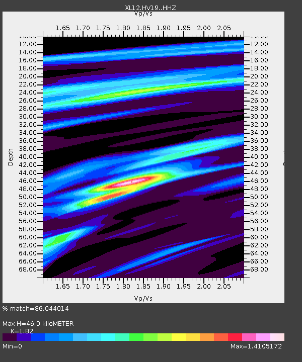
| Estimated Moho Depth: |
46.0 km |
| Estimated Crust Vp/Vs: |
1.82 |
| Assumed Crust Vp: |
6.419 km/s |
| Estimated Crust Vs: |
3.527 km/s |
| Estimated Crust Poisson's Ratio: |
0.28 |
|
| Radial Match: |
86.044014 % |
| Radial Bump: |
400 |
| Transverse Match: |
75.770065 % |
| Transverse Bump: |
400 |
| SOD ConfigId: |
7422571 |
| Insert Time: |
2019-04-20 00:34:47.064 +0000 |
| GWidth: |
2.5 |
| Max Bumps: |
400 |
| Tol: |
0.001 |
|

Signal To Noise
| Channel | StoN | STA | LTA |
| XL:HV19: :HHZ:20150727T07:49:08.758987Z | 2.6087756 | 3.6623152E-7 | 1.4038444E-7 |
| XL:HV19: :HHN:20150727T07:49:08.758987Z | 1.1692911 | 1.709742E-7 | 1.462204E-7 |
| XL:HV19: :HHE:20150727T07:49:08.758987Z | 1.2282898 | 1.2562595E-7 | 1.0227712E-7 |
| Arrivals |
| Ps | 6.2 SECOND |
| PpPs | 19 SECOND |
| PsPs/PpSs | 25 SECOND |


