You are here: Home > Network List > TA - USArray Transportable Network (new EarthScope stations) Stations List
> Station E62A Clayton Lake, ME, USA > Earthquake Result Viewer
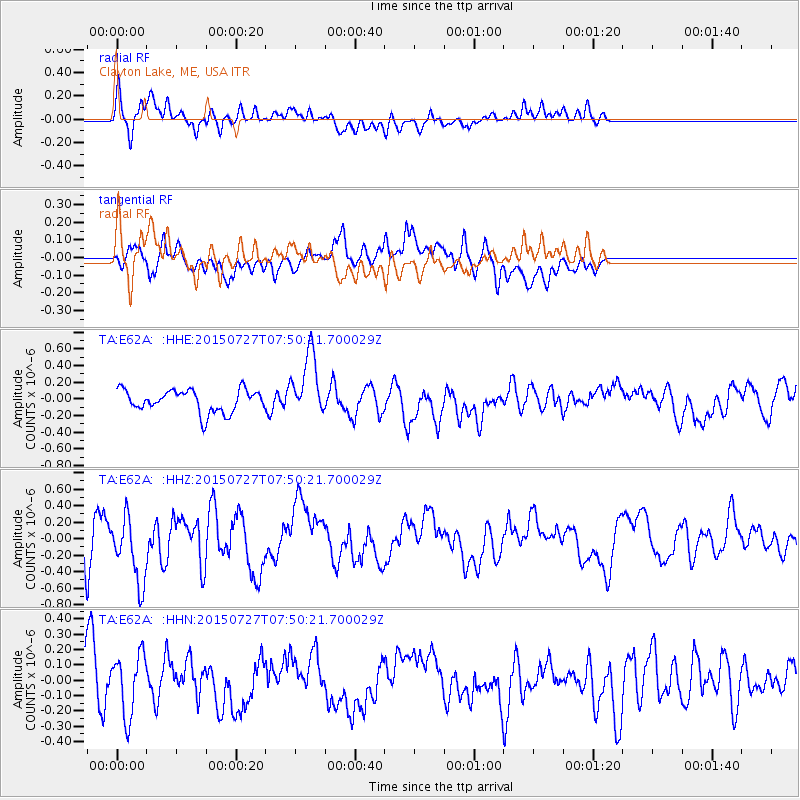
E62A Clayton Lake, ME, USA - Earthquake Result Viewer
*The percent match for this event was below the threshold and hence no stack was calculated.
| Earthquake location: |
Fox Islands, Aleutian Islands |
| Earthquake latitude/longitude: |
52.3/-169.1 |
| Earthquake time(UTC): |
2015/07/27 (208) 07:40:49 GMT |
| Earthquake Depth: |
33 km |
| Earthquake Magnitude: |
5.5 mb |
| Earthquake Catalog/Contributor: |
ISC/ISC |
|
| Network: |
TA USArray Transportable Network (new EarthScope stations) |
| Station: |
E62A Clayton Lake, ME, USA |
| Lat/Lon: |
46.62 N/69.52 W |
| Elevation: |
356 m |
|
| Distance: |
59.9 deg |
| Az: |
51.758 deg |
| Baz: |
315.578 deg |
| Ray Param: |
$rayparam |
*The percent match for this event was below the threshold and hence was not used in the summary stack. |
|
| Radial Match: |
67.05649 % |
| Radial Bump: |
400 |
| Transverse Match: |
51.62182 % |
| Transverse Bump: |
400 |
| SOD ConfigId: |
7422571 |
| Insert Time: |
2019-04-20 00:42:27.809 +0000 |
| GWidth: |
2.5 |
| Max Bumps: |
400 |
| Tol: |
0.001 |
|
Signal To Noise
| Channel | StoN | STA | LTA |
| TA:E62A: :HHZ:20150727T07:50:21.700029Z | 2.2371511 | 4.0588503E-7 | 1.8142941E-7 |
| TA:E62A: :HHN:20150727T07:50:21.700029Z | 2.0460253 | 1.9992906E-7 | 9.7715834E-8 |
| TA:E62A: :HHE:20150727T07:50:21.700029Z | 2.8433497 | 3.8101277E-7 | 1.3400138E-7 |
| Arrivals |
| Ps | |
| PpPs | |
| PsPs/PpSs | |


